Google Earth Engine ——Google Earth Engine ——ALOS World 3D - 30m (AW3D30) 是一个全球数字表面模型 (DSM) V2_2版本数据集
Google Earth Engine ——Google Earth Engine ——ALOS World 3D - 30m (AW3D30) 是一个全球数字表面模型 (DSM) V2_2版本数据集

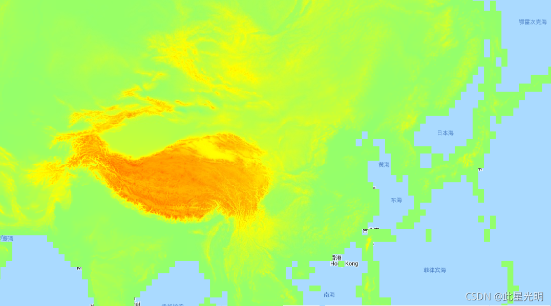
ALOS World 3D - 30m (AW3D30) is a global digital surface model (DSM) dataset with a horizontal resolution of approximately 30 meters (1 arcsec mesh). The dataset is based on the DSM dataset (5-meter mesh version) of the World 3D Topographic Data. More details are available in the dataset documentation.
Version 2.2, released in April 2019 is an improved version of the northern region over 60 degrees north. Along with the complement of no-data or low-quality area, updating of coastline was also performed.
The AW3D DSM elevation is calculated by an image matching process that uses a stereo pair of optical images. Clouds, snow, and ice are automatically identified during processing and applied the mask information. However, mismatched points sometimes remain especially surrounding (or at the edges of) clouds, snow, and ice areas, which cause some height errors in the final DSM. Here are some example areas with data values outside of valid elevation range. Impossibly low negative values are concentrated in Antarctica around (-63.77, -61.660), (-77.22, -150.27), and (-73.29, 168.14); in Indonesia around (-5.36, 134.55); in Brazil around (-1.667113844, -50.6269684); and in Peru around (-10.45048137, -75.39459876) with approximate values of -1013, -998, -635, and -610 respectively. Impossibly high positive values are found in several locations in the Arctic around (79.83, -77.67) and (69.54, -75.42); in Fiji around (-16.58, 179.44) and (-18.96, 178.39); and in Nepal around (28.50, 84.56) with approximate values of 15369, 15213, and 10900 respectively.
ALOS World 3D - 30m (AW3D30) 是一个全球数字表面模型 (DSM) 数据集,水平分辨率约为 30 米(1 弧秒网格)。该数据集基于 World 3D Topographic Data 的 DSM 数据集(5 米网格版本)。数据集文档中提供了更多详细信息。2019 年 4 月发布的 2.2 版是对北纬 60 度以上的北部地区的改进版本。在补充无数据或低质量区域的同时,还进行了海岸线的更新。
AW3D DSM 高程是通过使用一对立体光学图像的图像匹配过程计算出来的。云、雪和冰在处理过程中自动识别并应用蒙版信息。然而,不匹配的点有时会特别存在于云、雪和冰区周围(或边缘),这会导致最终 DSM 中出现一些高度错误。以下是一些数据值超出有效海拔范围的示例区域。极低的负值集中在南极洲 (-63.77, -61.660)、(-77.22, -150.27) 和 (-73.29, 168.14) 附近;在印度尼西亚附近 (-5.36, 134.55);在巴西附近 (-1.667113844, -50.6269684);在秘鲁 (-10.45048137, -75.39459876) 附近,近似值分别为 -1013、-998、-635 和 -610。在北极的几个位置(79.83,-77.67)和(69.54,-75.42)附近发现了不可能的高正值;在斐济大约 (-16.58, 179.44) 和 (-18.96, 178.39);在尼泊尔 (28.50, 84.56) 附近,近似值分别为 15369、15213 和 10900。Dataset Availability
2006-01-24T00:00:00 - 2011-05-12T00:00:00
Dataset Provider
JAXA Earth Observation Research Center
Collection Snippet
Copied
ee.Image("JAXA/ALOS/AW3D30/V2_2")
Resolution
30 meters
Bands Table
Name | Description | Min* | Max* |
|---|---|---|---|
AVE_DSM | Height above sea level. Signed 16 bits (Little endian) raster data. Elevation (in meter) converted from the ellipsoidal height based on ITRF97 and GRS80, using EGM96†1 geoid model. | -1054 | 15355 |
AVE_STK | Stacking number of the scene unit DSM used in producing DSM. The band is derived by resampling the stacking number for 5m resolution DSM to 30m resolution. | 0 | 54 |
AVE_MSK | 8-bit mask for the ave band. | ||
AVE_MSK Bitmask | Bits 0-7: Generated from resampled DSM. 0: Valid1: Cloud and snow mask (invalid).2: Land water and low correlation mask (valid).3: Sea mask (valid).4: Void filled with GSI DTM (valid).8: Void filled with Shuttle Radar Topography Mission SRTM-1 Version 3 (valid).12: Void filled with PRISM DSM (valid).24: Void filled with ASTER GDEM v2 (valid).28: Void filled with ArcticDEM v2 (valid).252: Void filled with applied IDW method (gdal_fillnodata) (valid) | ||
- Bits 0-7: Generated from resampled DSM.
- 0: Valid
- 1: Cloud and snow mask (invalid).
- 2: Land water and low correlation mask (valid).
- 3: Sea mask (valid).
- 4: Void filled with GSI DTM (valid).
- 8: Void filled with Shuttle Radar Topography Mission SRTM-1 Version 3 (valid).
- 12: Void filled with PRISM DSM (valid).
- 24: Void filled with ASTER GDEM v2 (valid).
- 28: Void filled with ArcticDEM v2 (valid).
- 252: Void filled with applied IDW method (gdal_fillnodata) (valid)
* = Values are estimated
数据引用说明:
This dataset is available to use with no charge under the conditions specified in the Terms of use for ALOS Global Digital Surface Model.
T. Tadono, H. Ishida, F. Oda, S. Naito, K. Minakawa, H. Iwamoto : Precise Global DEM Generation By ALOS PRISM, ISPRS Annals of the Photogrammetry, Remote Sensing and Spatial Information Sciences, Vol.II-4, pp.71-76, 2014. PDF file
J. Takaku, T. Tadono, K. Tsutsui : Generation of High Resolution Global DSM from ALOS PRISM, The International Archives of the Photogrammetry, Remote Sensing and Spatial Information Sciences, Vol. XL-4, pp.243-248, ISPRS, 2014. PDF file
J. Takaku, T. Tadono, K. Tsutsui, M. Ichikawa : Validation of ‘AW3D’ Global DSM Generated from ALOS PRISM, ISPRS Annals of the Photogrammetry, Remote Sensing and Spatial Information Sciences, Vol.III-4, pp.25-31, 2016. PDF file
T. Tadono, H. Nagai, H. Ishida, F. Oda, S. Naito, K. Minakawa, H. Iwamoto : Initial Validation of the 30 m-mesh Global Digital Surface Model Generated by ALOS PRISM, The International Archives of the Photogrammetry, Remote Sensing and Spatial Information Sciences, ISPRS, Vol. XLI-B4, pp.157-162, 2016. PDF file
代码:
var dataset = ee.Image('JAXA/ALOS/AW3D30/V2_2');
var elevation = dataset.select('AVE_DSM');
var elevationVis = {
  min: -9999,
  max: 15355,
  palette: ['0000ff', '00ffff', 'ffff00', 'ff0000', 'ffffff'],
};
Map.setCenter(136.85, 37.37, 4);
Map.addLayer(elevation, elevationVis, 'Elevation');