Google Earth Engine ——MYD13Q1.006 Aqua Vegetation Indices 16-Day Global 250m分辨率(NDVI/EVI)数据集
Google Earth Engine ——MYD13Q1.006 Aqua Vegetation Indices 16-Day Global 250m分辨率(NDVI/EVI)数据集

The MYD13Q1 V6 product provides a Vegetation Index (VI) value at a per pixel basis. There are two primary vegetation layers. The first is the Normalized Difference Vegetation Index (NDVI) which is referred to as the continuity index to the existing National Oceanic and Atmospheric Administration-Advanced Very High Resolution Radiometer (NOAA-AVHRR) derived NDVI. The second vegetation layer is the Enhanced Vegetation Index (EVI) that minimizes canopy background variations and maintains sensitivity over dense vegetation conditions. The EVI also uses the blue band to remove residual atmosphere contamination caused by smoke and sub-pixel thin cloud clouds. The MODIS NDVI and EVI products are computed from atmospherically corrected bi-directional surface reflectances that have been masked for water, clouds, heavy aerosols, and cloud shadows.
Documentation:
MYD13Q1 V6产品在每个像素的基础上提供植被指数(VI)值。有两个主要的植被层。第一个是归一化植被指数(NDVI),它被称为现有的国家海洋和大气管理局-高级甚高分辨率辐射计(NOAA-AVHRR)得出的NDVI的连续性指数。第二个植被层是增强植被指数(EVI),它将树冠背景变化降到最低,并保持对茂密植被条件的敏感性。EVI还使用蓝色波段来消除由烟雾和亚像素薄云造成的残留大气污染。MODIS NDVI和EVI产品是由经过大气校正的双向表面反射率计算出来的,这些反射率已经屏蔽了水、云、重气溶胶和云阴影。
Dataset Availability
2002-07-04T00:00:00 - 2021-09-06T00:00:00
Dataset Provider
NASA LP DAAC at the USGS EROS Center
Collection Snippet
ee.ImageCollection("MODIS/006/MYD13Q1")
Resolution
250 meters
Bands Table
Name | Description | Min | Max | Units | Wavelength | Scale |
|---|---|---|---|---|---|---|
NDVI | Normalized Difference Vegetation Index | -2000 | 10000 | 0.0001 | ||
EVI | Enhanced Vegetation Index | -2000 | 10000 | 0.0001 | ||
DetailedQA | VI quality indicators | 0 | ||||
DetailedQA Bitmask | Bits 0-1: VI quality (MODLAND QA Bits) 0: VI produced with good quality1: VI produced, but check other QA2: Pixel produced, but most probably cloudy3: Pixel not produced due to other reasons than cloudsBits 2-5: VI usefulness 0: Highest quality1: Lower quality2: Decreasing quality4: Decreasing quality8: Decreasing quality9: Decreasing quality10: Decreasing quality12: Lowest quality13: Quality so low that it is not useful14: L1B data faulty15: Not useful for any other reason/not processedBits 6-7: Aerosol Quantity 0: Climatology1: Low2: Intermediate3: HighBit 8: Adjacent cloud detected 0: No1: YesBit 9: Atmosphere BRDF correction 0: No1: YesBit 10: Mixed Clouds 0: No1: YesBits 11-13: Land/water mask 0: Shallow ocean1: Land (nothing else but land)2: Ocean coastlines and lake shorelines3: Shallow inland water4: Ephemeral water5: Deep inland water6: Moderate or continental ocean7: Deep oceanBit 14: Possible snow/ice 0: No1: YesBit 15: Possible shadow 0: No1: Yes | |||||
sur_refl_b01 | Red surface reflectance | 0 | 10000 | 645nm | 0.0001 | |
sur_refl_b02 | NIR surface reflectance | 0 | 10000 | 858nm | 0.0001 | |
sur_refl_b03 | Blue surface reflectance | 0 | 10000 | 469nm | 0.0001 | |
sur_refl_b07 | MIR surface reflectance | 0 | 10000 | 2130nm/2105 - 2155nm | 0.0001 | |
ViewZenith | View zenith angle | 0 | 18000 | Degrees | 0.01 | |
SolarZenith | Solar zenith angle | 0 | 18000 | Degrees | 0.01 | |
RelativeAzimuth | Relative azimuth angle | -18000 | 18000 | Degrees | 0.01 | |
DayOfYear | Julian day of year | 1 | 366 | 0 | ||
SummaryQA | Quality reliability of VI pixel | 0 | ||||
SummaryQA Bitmask | Bits 0-1: VI quality (MODLAND QA Bits) 0: Good data, use with confidence1: Marginal data, useful but look at detailed QA for more information2: Pixel covered with snow/ice3: Pixel is cloudy | |||||
- Bits 0-1: VI quality (MODLAND QA Bits)
- 0: VI produced with good quality
- 1: VI produced, but check other QA
- 2: Pixel produced, but most probably cloudy
- 3: Pixel not produced due to other reasons than clouds
- Bits 2-5: VI usefulness
- 0: Highest quality
- 1: Lower quality
- 2: Decreasing quality
- 4: Decreasing quality
- 8: Decreasing quality
- 9: Decreasing quality
- 10: Decreasing quality
- 12: Lowest quality
- 13: Quality so low that it is not useful
- 14: L1B data faulty
- 15: Not useful for any other reason/not processed
- Bits 6-7: Aerosol Quantity
- 0: Climatology
- 1: Low
- 2: Intermediate
- 3: High
- Bit 8: Adjacent cloud detected
- 0: No
- 1: Yes
- Bit 9: Atmosphere BRDF correction
- 0: No
- 1: Yes
- Bit 10: Mixed Clouds
- 0: No
- 1: Yes
- Bits 11-13: Land/water mask
- 0: Shallow ocean
- 1: Land (nothing else but land)
- 2: Ocean coastlines and lake shorelines
- 3: Shallow inland water
- 4: Ephemeral water
- 5: Deep inland water
- 6: Moderate or continental ocean
- 7: Deep ocean
- Bit 14: Possible snow/ice
- 0: No
- 1: Yes
- Bit 15: Possible shadow
- 0: No
- 1: Yes
sur_refl_b01Red surface reflectance010000645nm0.0001sur_refl_b02NIR surface reflectance010000858nm0.0001sur_refl_b03Blue surface reflectance010000469nm0.0001sur_refl_b07MIR surface reflectance0100002130nm/2105 - 2155nm0.0001ViewZenithView zenith angle018000Degrees0.01SolarZenithSolar zenith angle018000Degrees0.01RelativeAzimuthRelative azimuth angle-1800018000Degrees0.01DayOfYearJulian day of year13660SummaryQAQuality reliability of VI pixel0SummaryQA Bitmask
- Bits 0-1: VI quality (MODLAND QA Bits)
- 0: Good data, use with confidence
- 1: Marginal data, useful but look at detailed QA for more information
- 2: Pixel covered with snow/ice
- 3: Pixel is cloudy
使用说明:
MODIS data and products acquired through the LP DAAC have no restrictions on subsequent use, sale, or redistribution.
代码:
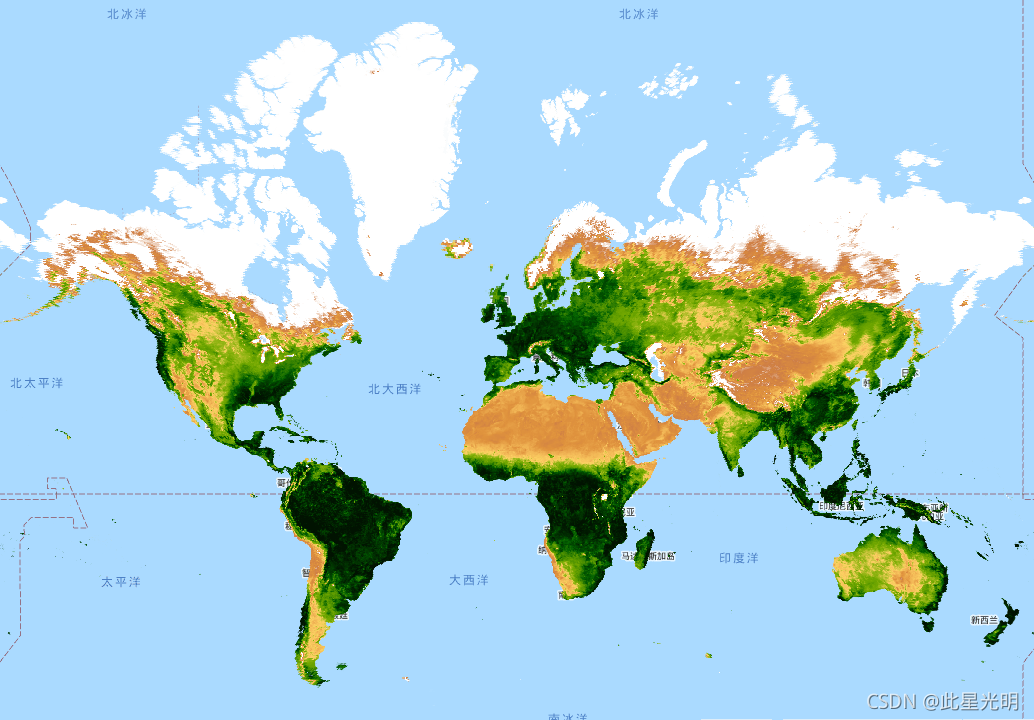
var dataset = ee.ImageCollection('MODIS/006/MYD13Q1')
                  .filter(ee.Filter.date('2018-01-01', '2018-05-01'));
var ndvi = dataset.select('NDVI');
var ndviVis = {
  min: 0.0,
  max: 8000.0,
  palette: [
    'FFFFFF', 'CE7E45', 'DF923D', 'F1B555', 'FCD163', '99B718', '74A901',
    '66A000', '529400', '3E8601', '207401', '056201', '004C00', '023B01',
    '012E01', '011D01', '011301'
  ],
};
Map.setCenter(6.746, 46.529, 2);
Map.addLayer(ndvi, ndviVis, 'NDVI');