Google Earth Engine——Landsat植被连续场(VCF)树木覆盖层包含了每个30米像素中被高度大于5米的木质植被覆盖的水平地面的百分比估计,数据集来自GFCC表面反射率产品
Google Earth Engine——Landsat植被连续场(VCF)树木覆盖层包含了每个30米像素中被高度大于5米的木质植被覆盖的水平地面的百分比估计,数据集来自GFCC表面反射率产品

The Landsat Vegetation Continuous Fields (VCF) tree cover layers contain estimates of the percentage of horizontal ground in each 30-m pixel covered by woody vegetation greater than 5 meters in height. The dataset is available for four epochs centered on the years 2000, 2005, 2010 and 2015. The dataset is derived from the GFCC Surface Reflectance product (GFCC30SR), which is based on enhanced Global Land Survey (GLS) datasets. The GLS datasets are composed of high-resolution Landsat 5 Thematic Mapper (TM) and Landsat 7 Enhanced Thematic Mapper Plus (ETM+) images at 30 meter resolution.
Tree cover, the proportional, vertically projected area of vegetation (including leaves, stems, branches, etc.) of woody plants above a given height, affects terrestrial energy and water exchanges, photosynthesis and transpiration, net primary production, and carbon and nutrient fluxes. Tree cover also affects habitat quality and movements of wildlife, residential property value for humans, and other ecosystem services. The continuous classification scheme of the VCF product enables better depiction of land cover gradients than traditional discrete classification schemes. Importantly for detection and monitoring of forest changes (e.g., deforestation and degradation), tree cover provides a measurable attribute upon which to define forest cover and its changes. Changes in tree cover over time can be used to monitor and retrieve site-specific histories of forest change.
The dataset has been produced for four year epochs: 2000, 2005, 2010, and 2015 with an image in the collection for each available WRS2 path/row.
Documentation:
- User's guide
- [Algorithm Theoretical Basis Document (ATBD)](https://lpdaac.usgs.gov/documents/146/GFCC_ATBD.pdf
Provider's Note: Due to the end of NASA MEaSUREs funding, free versions of this dataset are no longer being produced. Interested parties can obtain updated and expanded versions at www.terraPulse.com.
Landsat植被连续场(VCF)树木覆盖层包含了每个30米像素中被高度大于5米的木质植被覆盖的水平地面的百分比估计。该数据集可用于以2000年、2005年、2010年和2015年为中心的四个纪元。该数据集来自GFCC表面反射率产品(GFCC30SR),该产品基于增强的全球土地调查(GLS)数据集。GLS数据集由高分辨率的Landsat 5 Thematic Mapper(TM)和Landsat 7 Enhanced Thematic Mapper Plus(ETM+)图像组成,分辨率为30米。
树木覆盖率,即一定高度以上的木本植物的植被(包括叶子、茎、枝条等)的比例、垂直投影面积,影响陆地能量和水的交换、光合作用和蒸腾作用、净初级生产以及碳和营养物质的通量。树木覆盖还影响到野生动物的栖息地质量和移动、人类的住宅财产价值以及其他生态系统服务。与传统的离散分类方案相比,VCF产品的连续分类方案能够更好地描述土地覆盖梯度。对于检测和监测森林变化(如森林砍伐和退化)来说,重要的是,树木覆盖提供了一个可测量的属性,可以据此定义森林覆盖及其变化。树木覆盖率随时间的变化可用于监测和检索特定地点的森林变化历史。
该数据集为四个年份制作:2000年、2005年、2010年和2015年,每个可用的WRS2路径/行都有一张图片。
文件。
用户指南
[算法理论基础文件(ATBD)](https://lpdaac.usgs.gov/documents/146/GFCC_ATBD.pdf
提供者注:由于NASA MEaSUREs资助的结束,该数据集的免费版本已不再制作。有兴趣的人可以在www.terraPulse.com,获得更新和扩展的版本。
Dataset Availability
2000-01-01T00:00:00 - 2015-12-31T00:00:00
Dataset Provider
NASA LP DAAC at the USGS EROS Center
Collection Snippet
ee.ImageCollection("NASA/MEASURES/GFCC/TC/v3")
Resolution
30 meters
Bands Table
Name | Description | Min | Max | Units |
|---|---|---|---|---|
tree_canopy_cover | The percentage of pixel area covered by trees. | 0 | 100 | % |
uncertainty | RMSE for tree-canopy_cover | |||
source_index | Identity of source image used for the particular pixel. This is an index into the per image metadata array 'sources'. Only available for 2000, 2005, and 2010. |
影像属性:
Name | Type | Description |
|---|---|---|
path | Double | Path |
pathrow | String | Path and row |
row | Double | Row |
sources | Double | Sources. Only available for 2000, 2005, and 2010. |
tree_canopy_cover_class_palette | Double | Tree canopy cover class palette |
tree_canopy_cover_class_values | Double | Tree canopy cover class values |
year | Double | Year |
数据引用:
Paper/Methods Citation: Sexton, J. O., Song, X.-P., Feng, M., Noojipady, P., Anand, A., Huang, C., Kim, D.-H., Collins, K.M., Channan, S., DiMiceli, C., Townshend, J.R.G. (2013). Global, 30-m resolution continuous fields of tree cover: Landsat-based rescaling of MODIS Vegetation Continuous Fields with lidar-based estimates of error. International Journal of Digital Earth, 130321031236007. doi:10.1080/17538947.2013.786146.
代码:
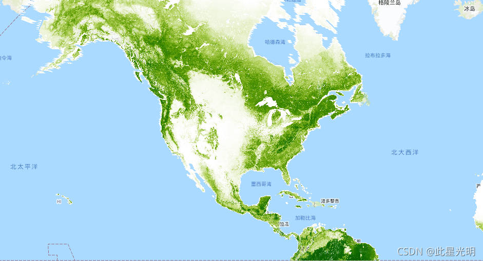
var dataset = ee.ImageCollection('NASA/MEASURES/GFCC/TC/v3')
                  .filter(ee.Filter.date('2015-01-01', '2015-12-31'));
var treeCanopyCover = dataset.select('tree_canopy_cover');
var treeCanopyCoverVis = {
  min: 0.0,
  max: 100.0,
  palette: ['ffffff', 'afce56', '5f9c00', '0e6a00', '003800'],
};
Map.setCenter(-88.6, 26.4, 3);
Map.addLayer(treeCanopyCover.mean(), treeCanopyCoverVis, 'Tree Canopy Cover');