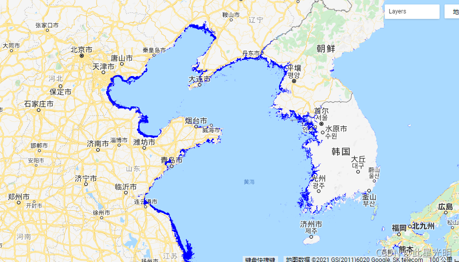
Google Earth Engine——Murray Global Intertidal Change ClassificationMurray全球潮间带变化数据集
Google Earth Engine——Murray Global Intertidal Change ClassificationMurray全球潮间带变化数据集

The Murray Global Intertidal Change Dataset contains global maps of tidal flat ecosystems produced via a supervised classification of 707,528 Landsat Archive images. Each pixel was classified into tidal flat, permanent water or other with reference to a globally distributed set of training data.
The classification was implemented along the entire global coastline between 60° North and 60° South from 1 January 1984 to 31 December 2016. The image collection consists consists of a time-series of 11 global maps of tidal flats at 30m pixel resolution for set time-periods (1984−1986; 1987−1989; 1990−1992; 1993−1995; 1996−1998; 1999−2001; 2002−2004; 2005−2007; 2008−2010; 2011−2013; 2014−2016)
This product depicts tidal flat ecosystems around the global coastline.
Pixels classified as tidal flat in the analysis represent several types of tidal flat ecosystems, including unconsolidated fine-grain sediments (tidal mudflats), unconsolidated coarse-grain sediments (tidal sand flats), and consolidated sediments, organic material or rocks (wide tidal rock-platforms), while excluding spectral signatures indicating the presence of vegetation dominated intertidal ecosystems such as mangroves and vegetated marshes. The analysis aimed to identify pixels that are subject to regular tidal inundation, and therefore may also include other intertidal systems where intertidal dynamics are observable.
Murray全球潮间带变化数据集包含了通过对707,528张Landsat Archive图像进行监督分类而产生的全球潮间带生态系统地图。参照全球分布的训练数据集,每个像素都被划分为潮滩、永久水域或其他。
1984年1月1日至2016年12月31日,分类工作沿着北纬60°和南纬60°之间的整个全球海岸线进行。该图像集包括11幅全球潮滩地图的时间序列,分辨率为30米,时间段为1984-1986;1987-1989;1990-1992;1993-1995;1996-1998;1999-2001;2002-2004;2005-2007;2008-2010;2011-2013;2014-2016)
该产品描述了全球海岸线周围的潮汐平地生态系统。
在分析中被归类为潮汐平地的像素代表了几种类型的潮汐平地生态系统,包括未固结的细粒沉积物(潮汐泥滩)、未固结的粗粒沉积物(潮汐沙滩)以及固结的沉积物、有机物质或岩石(宽大的潮汐岩石平台),同时排除了表明存在红树林和植被沼泽等植被主导的潮间生态系统的光谱特征。分析的目的是确定受定期潮汐淹没的像素,因此也可能包括其他可观察到潮汐动态的潮间带系统。
Dataset Availability
1984-01-01T00:00:00 - 2017-01-01T00:00:00
Dataset Provider
Collection Snippet
Copied
ee.ImageCollection("UQ/murray/Intertidal/v1_1/global_intertidal")
Resolution
30 meters
Bands Table
Name | Description | Units |
|---|---|---|
classification | Intertertidal area classification for the interval. | occurrence |
classification Bitmask | Bit 0: Intertidal area classification. 0: Classified non-intertidal area1: Classified intertidal area | |
- Bit 0: Intertidal area classification.
- 0: Classified non-intertidal area
- 1: Classified intertidal area
引用:
Murray, N.J., Phinn, S.R., DeWitt, M., Ferrari, R., Johnston, R., Lyons, M.B., Clinton, N., Thau, D. & Fuller, R.A. (2019) The global distribution and trajectory of tidal flats. Nature, 565, 222-225.
The global distribution and trajectory of tidal flats | Nature
代码:
var dataset = ee.ImageCollection('UQ/murray/Intertidal/v1_1/global_intertidal');

var visualization = {
  bands: ['classification'],
  min: 0.0,
  max: 1.0,
  palette: ['0000FF']
};

Map.setCenter(126.6339, 37.4394, 10);

Map.addLayer(dataset, visualization, 'Intertidal areas');