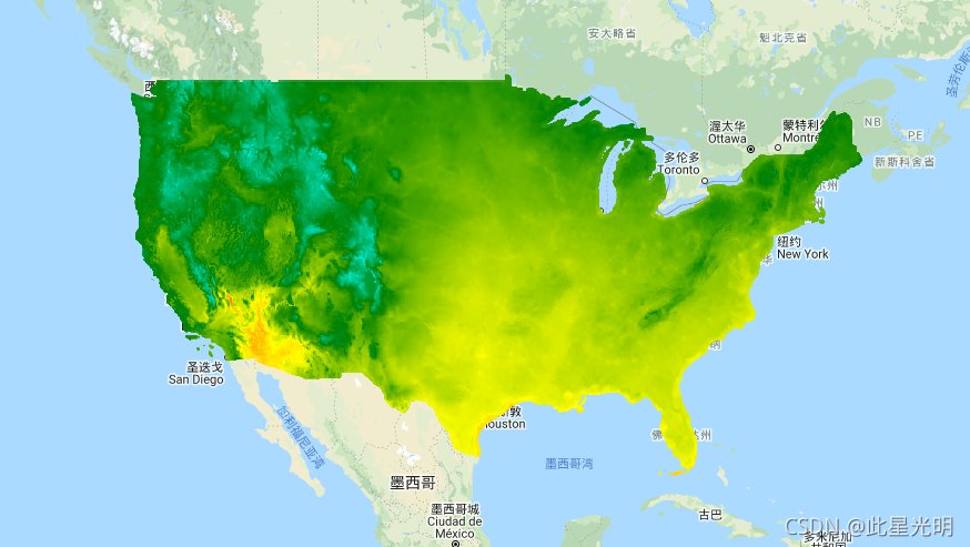
Google Earth Engine——美国1950-2099年降水、气温含预测数据集(1km)分辨率
Google Earth Engine——美国1950-2099年降水、气温含预测数据集(1km)分辨率

The NASA NEX-DCP30 dataset is comprised of downscaled climate scenarios for the conterminous United States that are derived from the General Circulation Model (GCM) runs conducted under the Coupled Model Intercomparison Project Phase 5 (CMIP5, see Taylor et al. 2012) and across the four greenhouse gas emissions scenarios known as Representative Concentration Pathways (RCPs, see Meinshausen et al. 2011) developed for the Fifth Assessment Report of the Intergovernmental Panel on Climate Change (IPCC AR5). The purpose of these datasets is to provide a set of high resolution, bias-corrected climate change projections that can be used to evaluate climate change impacts on processes that are sensitive to finer-scale climate gradients and the effects of local topography on climate conditions.
The dataset contains monthly projections covering the periods from 1950 through 2005 (Retrospective Run) and from 2006 to 2099 (Prospective Run). It includes ensemble statistics calculated for each RCP from all model runs available for the pr, tasmin, and tasmax bands.
NEX-DCP30 was prepared by the Climate Analytics Group and NASA Ames Research Center using the NASA Earth Exchange, and distributed by the NASA Center for Climate Simulation (NCCS).
NASA NEX-DCP30数据集由美国本土的降尺度气候情景组成,这些情景来自于在耦合模型相互比较项目第五阶段(CMIP5,见Taylor等人,2012年)下进行的一般循环模型(GCM)运行,以及为政府间气候变化专门委员会第五次评估报告(IPCC AR5)制定的四种温室气体排放情景,即代表浓度路径(RCPs,见Meinshausen等人,2011)。这些数据集的目的是提供一套高分辨率的、经过偏差校正的气候变化预测,可用于评估气候变化对那些对更精细的气候梯度和当地地形对气候条件影响敏感的过程的影响。
该数据集包含从1950年到2005年(回顾性运行)和从2006年到2099年(展望性运行)的每月预测。它包括来自33个模型的降尺度预测。并非每个情景都包含每个模型的预测。
NEX-DCP30由气候分析小组和NASA艾姆斯研究中心使用NASA地球交换系统编制,并由NASA气候模拟中心(NCCS)分发。
Dataset Availability
1950-01-01T00:00:00 - 2099-12-31T00:00:00
Dataset Provider
Collection Snippet
ee.ImageCollection("NASA/NEX-DCP30_ENSEMBLE_STATS")
Resolution
927.67 meters
Bands Table
Name | Description | Min* | Max* | Units |
|---|---|---|---|---|
pr_mean | Monthly mean of the daily precipitation rate at surface; includes both liquid and solid phases from all types of clouds (both large-scale and convective) | 0 | 0.0006 | kg/(m^2*s) |
pr_quartile25 | 25th quartile of the precipitation at surface; includes both liquid and solid phases from all types of clouds (both large-scale and convective) | 0 | 0.0004 | kg/(m^2*s) |
pr_median | Median of precipitation at surface; includes both liquid and solid phases from all types of clouds (both large-scale and convective) | 0 | 0.0006 | kg/(m^2*s) |
pr_quartile75 | 75th quartile of the precipitation at surface; includes both liquid and solid phases from all types of clouds (both large-scale and convective) | 0 | 0.0008 | kg/(m^2*s) |
tasmin_mean | Monthly mean of the daily-minimum near-surface air temperature | 247.58 | 311.09 | K |
tasmin_quartile25 | 25th quartile the daily-minimum near-surface air temperature | 243.28 | 310.06 | K |
tasmin_median | Median of the daily-minimum near-surface air temperature | 246.87 | 311.12 | K |
tasmin_quartile75 | 75th quartile of the daily-minimum near-surface air temperature | 248.42 | 312.59 | K |
tasmax_mean | Monthly mean of the daily-maximum near-surface air temperature | 258.47 | 326.48 | K |
tasmax_quartile25 | 25th quartile of the daily-maximum near-surface air temperature | 256.13 | 325.52 | K |
tasmax_median | Median of the daily-maximum near-surface air temperature | 257.89 | 326.28 | K |
tasmax_quartile75 | 75th quartile of the daily-maximum near-surface air temperature | 260.2 | 328.2 | K |
* = Values are estimated
影像属性:
Name | Type | Description |
|---|---|---|
scenario | String | Name of the CMIP5 scenario. It is one of: 'historical', 'rcp26', 'rcp45', 'rcp60', 'rcp85', where 'historical' designates retrospective model runs (pre-2006). |
month | Double | Calendar month |
引用:
Thrasher, B., J. Xiong, W. Wang, F. Melton, A. Michaelis and R. Nemani (2013), Downscaled Climate Projections Suitable for Resource Management, Eos Trans. AGU, 94(37), 321. doi:10.1002/2013EO370002
代码:
var dataset = ee.ImageCollection('NASA/NEX-DCP30_ENSEMBLE_STATS')
                  .filter(ee.Filter.date('2018-07-01', '2018-07-30'));
var monthlyMeanMinimumAirTemperature = dataset.select('tasmin_mean');
var monthlyMeanMinimumAirTemperatureVis = {
  min: 247.0,
  max: 311.0,
  palette: ['blue', 'purple', 'cyan', 'green', 'yellow', 'red'],
};
Map.setCenter(-115.356, 38.686, 5);
Map.addLayer(
    monthlyMeanMinimumAirTemperature, monthlyMeanMinimumAirTemperatureVis,
    'Monthly Mean Minimum Air Temperature');