
如何根据字符串值显示批注的不同图像
如何根据字符串值显示批注的不同图像
提问于 2012-05-27 08:35:55
我有一个包含多个注释的MapView。我需要根据data.plist中的字符串值将不同的图像放到注释中
我的当前代码(只用于一个类别,一个图像):
NSString *path = [[NSBundle mainBundle] pathForResource:@"data" ofType:@"plist"];
NSDictionary *dict = [NSDictionary dictionaryWithContentsOfFile:path];
NSArray *anns = [dict objectForKey:@"Category1"];
pinView.image = [UIImage imageNamed:[[anns objectAtIndex:0] objectForKey:@"Icon"]];
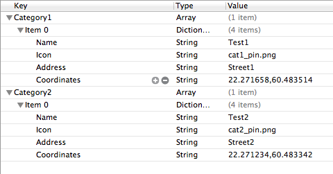
pinView.canShowCallout=YES;我的plist文件结构:
编辑
我的MapViewController.m
- (void)viewDidLoad
{
    [super viewDidLoad];


    NSMutableArray *annotations = [[NSMutableArray alloc]init];


    NSString *path = [[NSBundle mainBundle] pathForResource:@"data" ofType:@"plist"];
    NSDictionary *dict = [NSDictionary dictionaryWithContentsOfFile:path];


    NSArray *anns = [dict objectForKey:@"Category1"];

    NSLog(@" MapView is %@",mapView);
    NSLog(@"anns is: %@", anns);


    for(int i = 0; i < [anns count]; i++) {


        NSString *coordinates = [[anns objectAtIndex:i] objectForKey:@"Coordinates"];

        double realLatitude = [[[coordinates componentsSeparatedByString:@","] objectAtIndex:1] doubleValue];
        double realLongitude = [[[coordinates componentsSeparatedByString:@","] objectAtIndex:0] doubleValue];

        MyAnnotation *myAnnotation = [[MyAnnotation alloc] init];
        CLLocationCoordinate2D theCoordinate;
        theCoordinate.latitude = realLatitude;
        theCoordinate.longitude = realLongitude;


        //calculate distance
        CLLocationCoordinate2D annocoord = myAnnotation.coordinate;
        CLLocationCoordinate2D usercoord = self.mapView.userLocation.coordinate;

        NSLog(@"ANNO  = %f, %f", annocoord.latitude, annocoord.longitude);
        NSLog(@"USER = %f, %f", usercoord.latitude, usercoord.longitude);

        CLLocation *loc = [[CLLocation alloc] initWithLatitude:myAnnotation.coordinate.latitude longitude:myAnnotation.coordinate.longitude];
        CLLocation *loc2 = [[CLLocation alloc] initWithLatitude:self.mapView.userLocation.coordinate.latitude longitude:self.mapView.userLocation.coordinate.longitude];

        NSLog(@"LOC  = %f, %f", loc.coordinate.latitude,  loc.coordinate.longitude);
        NSLog(@"LOC2 = %f, %f", loc2.coordinate.latitude, loc2.coordinate.longitude);

        CLLocationDistance dist = [loc distanceFromLocation:loc2];

        NSLog(@"DIST: %f", dist);

        myAnnotation.coordinate=CLLocationCoordinate2DMake(realLatitude,realLongitude);
        myAnnotation.title = [[anns objectAtIndex:i] objectForKey:@"Name"];
        myAnnotation.subtitle = [NSString stringWithFormat:@"%.f", dist];


        [mapView addAnnotation:myAnnotation];
        [annotations addObject:myAnnotation];
    }


    NSArray *alko = [dict objectForKey:@"Category2"];

    NSLog(@" MapView is %@",mapView);
    NSLog(@"alko is: %@", alko);


    for(int i = 0; i < [alko count]; i++) {


        NSString *coordinates = [[alko objectAtIndex:i] objectForKey:@"Coordinates"];

        double realLatitude = [[[coordinates componentsSeparatedByString:@","] objectAtIndex:1] doubleValue];
        double realLongitude = [[[coordinates componentsSeparatedByString:@","] objectAtIndex:0] doubleValue];

        MyAnnotation *myAnnotation = [[MyAnnotation alloc] init];
        CLLocationCoordinate2D theCoordinate;
        theCoordinate.latitude = realLatitude;
        theCoordinate.longitude = realLongitude;

        myAnnotation.coordinate=CLLocationCoordinate2DMake(realLatitude,realLongitude);
        myAnnotation.title = [[alko objectAtIndex:i] objectForKey:@"Name"];
        myAnnotation.subtitle = [[alko objectAtIndex:i] objectForKey:@"Address"];


        [mapView addAnnotation:myAnnotation];
        [annotations addObject:myAnnotation];
    }


    self.locationManager = [[CLLocationManager alloc] init];
    self.locationManager.delegate = self;
    self.locationManager.desiredAccuracy = kCLLocationAccuracyBest;
    [self.locationManager startUpdatingLocation];

}
注解
- (MKAnnotationView *)mapView:(MKMapView *)mapView viewForAnnotation:(id <MKAnnotation>)annotation
{


    if ([annotation isKindOfClass:[MKUserLocation class]])
        return nil;


    static NSString* AnnotationIdentifier = @"AnnotationIdentifier";
    MKPinAnnotationView* pinView = [[MKPinAnnotationView alloc]
                                    initWithAnnotation:annotation reuseIdentifier:AnnotationIdentifier];


    NSString *path = [[NSBundle mainBundle] pathForResource:@"data" ofType:@"plist"];
    NSDictionary *dict = [NSDictionary dictionaryWithContentsOfFile:path];

    NSArray *anns = [dict objectForKey:@"Category1"];
    pinView.image = [UIImage imageNamed:[[anns objectAtIndex:0] objectForKey:@"Icon"]];

    pinView.canShowCallout=YES;


    return pinView;
}回答 1
Stack Overflow用户
回答已采纳
发布于 2012-05-27 09:29:52
这就是你需要的吗?
NSString *theCategory;

// set theCategory to what you need.
theCategory = @"Category1"

NSArray *anns = [dict objectForKey:theCategory];
编辑1
首先,最好将注释类设置为:
MyAnnotation.h
#import <MapKit/MapKit.h>

@interface MyAnnotation : NSManagedObject <MKAnnotation>{

CLLocationCoordinate2D coordinate;
UIImage *imageForMyAnnotation;
}

@property (nonatomic,readwrite) CLLocationCoordinate2D coordinate;
@property (nonatomic, retain) UIImage *imageForMyAnnotation;
MyAnnotation.m
#import "MyAnnotation.h"

@implementation MyAnnotation

- (CLLocationCoordinate2D)coordinate
{
//here you can set the coordinate of your annotation
return coordinate;
}

- (UIImage *)imageForMyAnnotation{
//set the image here, i think it is depend on the coordinate right? You can put some code here to chose the category that corresponding to the coordinate
return image;
}

// optional
- (NSString *)title
{
return title;
}
- (NSString *)subtitle
{
return subtitle;
}
然后,在您的mapView中,您可以使用
MapView.m
[self.mapView addAnnotations:myAnnotationArray];或
[self.mapView addAnnotation:myAnnotation];和
- (MKAnnotationView *)mapView:(MKMapView *)theMapView viewForAnnotation:(id <MKAnnotation>)annotation{

UIImageView *annotationImageView = [[UIImageView alloc] initWithImage: myAnnotation.imageForMyAnnotatioin];

customPinView.leftCalloutAccessoryView = annotationImageView;

}页面原文内容由Stack Overflow提供。腾讯云小微IT领域专用引擎提供翻译支持
原文链接:
https://stackoverflow.com/questions/10772701
复制相关文章
相似问题
腾讯云开发者
