
在给定坐标和最大距离查询结果的情况下,用平均堆栈Mongoose查找与某个点最近的点。
我有些日子没能解决的问题,甚至看看相关的堆栈溢出Q/A。
我正在开发一个重用Scotch's Create Stack Google Map App教程由Ahmed Haque编写方法的应用程序。
我正在尝试实现一个应用程序,它使用Google 绘制Points、LineStrings和Polygons,这些坐标包含在存储在MongoDB实例中的GeoJson文件中。
我正在使用Mongoose为我的数据构建模式并查询我的MongoDB数据库。
我想找出最近的点,
CP到某个点,P0,给定P0's latitude and longitude,给出一个最大半径,distance,用来找到感兴趣的点。
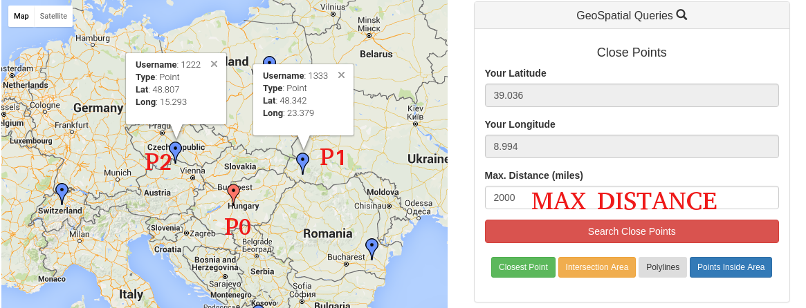
考虑到图像结束,我想要这样做,例如,如果我插入2000 (公里),我的查询将找到距P0最大2000公里的所有点。在本例中,它可能会给我P1和P2。
当我的Mongoose Schema中只有点数时,我才能做到这一点。
我有这个Schema ,只有标记(点)
// Pulls Mongoose dependency for creating schemas
var mongoose    = require('mongoose');
var Schema      = mongoose.Schema;

// Creates a User Schema.
var MarkerSchema = new Schema({
    username: {type: String, required: true},
    location: {type: [Number], required: true}, // [Long, Lat]
    created_at: {type: Date, default: Date.now},
    updated_at: {type: Date, default: Date.now}
});

// Indexes this schema in 2dsphere format
MarkerSchema.index({location: '2dsphere'});

module.exports = mongoose.model('mean-markers', MarkerSchema);这是我的Old Query for only Markers**:**
var User = require('./model.js');

app.post('/query/', function(req, res) {

        // Grab all of the query parameters from the body.
        var lat = req.body.latitude;
        var long = req.body.longitude;
        var distance = req.body.distance;
        var reqVerified = req.body.reqVerified;

        // Opens a generic Mongoose Query
        var query = User.find({});

        // ...include filter by Max Distance (converting miles to meters)
        if (distance) {

            // Using MongoDB's geospatial querying features
            query = query.where('location').near({
                center: {
                    type: 'Point',
                    coordinates: [long, lat]
                },

                // Converting meters to miles
                maxDistance: distance * 1609.34,
                spherical: true
            });
        }
});
它真的很好,我能够得到接近的观点。
然后,我将我的Schema更改为更动态,并支持Polylines and Polygons。
我可以插入和绘制新的点,多边形和多边形,用下面的Schema**:**
var mongoose = require('mongoose');
var GeoJSON  = require('geojson');
var Schema   = mongoose.Schema;

// Creates a Location Schema.
var LocationSchema = new Schema({
                                    name: {type: String, required: true},
                                    location: {
                                      type: {type : String, required: true},
                                      coordinates : [Schema.Types.Mixed]
                                    },
                                    created_at: {type: Date, default: Date.now},
                                    updated_at: {type: Date, default: Date.now}
});

LocationSchema.index({location: '2dsphere'});
module.exports = mongoose.model('mean-locations', LocationSchema);这是我的Mongoose Query**:**
var GeoObjects = require('./model.js');

app.post('/query/', function(req, res) {

    // Grab all of the query parameters from the body.
    var lat = req.body.latitude;
    var long = req.body.longitude;
    var distance = req.body.distance;

    var query;

    if (distance) {
        query = GeoObjects.find({'location.type':'Point'})
                    .where('location.coordinates').near({
                      center: {
                        type: 'Point',
                        coordinates: [lat, long]
                      },
                      // Converting meters to miles
                      maxDistance: distance * 1609.34,
                      spherical: true
        });
    }

    // Execute Query and Return the Query Results
    query.exec(function(err, users) {
        if (err)
            res.send(err);
        console.log(users);
        // If no errors, respond with a JSON of all users that meet the criteria
        res.json(users);
    });
});console.log(users);给了我undefined.
在我的queryCtrl.js中记录查询结果会给出以下错误消息:
name: "MongoError", message: "error processing query: ns=MeanMapApp.mean-locatio…ed error: unable to find index for $geoNear query", waitedMS: 0, ok: 0, errmsg: "error processing query: ns=MeanMapApp.mean-locatio…ed error: unable to find index for $geoNear query"
与略有差异相同:
app.post('/query/', function(req, res) {

    // Grab all of the query parameters from the body.
    var lat = req.body.latitude;
    var long = req.body.longitude;
    var distance = req.body.distance;

    console.log(lat,long,distance);

    var points = GeoObjects.find({'location.type':'Point'});

    var loc = parseFloat(points.location.coordinates);
    console.log(JSON.stringify(loc));

    if (distance) {
        var query = points.near(loc, {
                      center: {
                        type: 'Point',
                        coordinates: [parseFloat(lat), parseFloat(long)]
                      },
                      // Converting meters to miles
                      maxDistance: distance * 1609.34,
                      spherical: true
        });
    }
});
这是一个标记的例子:
{
  "name": "user01",
  "location": {
                "type":"Point",
                "coordinates": [102.0, 0.0]

  }
}$near运算符如何与距离和maxDistance:一起工作
MongoDB搜索参数$near及其相关属性maxDistance和球形,以指定我们要覆盖的范围。我们将查询体的距离乘以1609.34,因为我们希望将用户的输入(以英里为单位)转换为MongoDB期望的单位(以米为单位)。
- 为什么我要得到
undefined**?** - 这个问题有可能是由我的架构引起的吗?
- ,我怎样才能解决这个问题?
如果你想得到一些澄清,只需在下面发表评论。
提前谢谢。
回答 2
Stack Overflow用户
发布于 2016-06-20 18:52:54
我终于解决了这个问题。
本质上,这个问题是由模式引起的,因为2dIndex被引用到了一个错误的字段(type and coordinates)。
我使用以下架构进行了求解
var mongoose = require('mongoose');
var GeoJSON  = require('geojson');
var Schema   = mongoose.Schema;

var geoObjects = new Schema({
                               name : {type: String},
                               type: {
                                       type: String,
                                       enum: [
                                               "Point",
                                               "LineString",
                                               "Polygon"
                                             ]
                                      },
                                coordinates: [Number],
                                created_at: {type: Date, default: Date.now},
                                updated_at: {type: Date, default: Date.now}
});

// Sets the created_at parameter equal to the current time
geoObjects.pre('save', function(next){
   now = new Date();
   this.updated_at = now;
   if(!this.created_at) {
      this.created_at = now
   }
   next();
});

geoObjects.index({coordinates: '2dsphere'});

module.exports = mongoose.model('geoObjects', geoObjects);和下面的查询
app.post('/query/', function(req, res) {

        // Grab all of the query parameters from the body.
        var lat = req.body.latitude;
        var long = req.body.longitude;
        var distance = req.body.distance;

        var query = GeoObjects.find({'type':'Point'});

        // ...include filter by Max Distance
        if (distance) {

            // Using MongoDB's geospatial querying features.
            query = query.where('coordinates').near({
                center: {
                    type: 'Point',
                    coordinates: [lat, long]
                },

                // Converting meters to miles
                maxDistance: distance * 1609.34,
                spherical: true
            });
        }

        // Execute Query and Return the Query Results
        query.exec(function(err, geoObjects) {
            if (err)
                res.send(err);

            // If no errors, respond with a JSON
            res.json(geoObjects);
        });
    });
我希望它能帮到别人!
编辑
我所介绍的模式会给LineStrings和Polygons带来一些问题。
以下是允许使用geoQueries的正确模式
linestring-model.js:
var mongoose = require('mongoose');
var Schema   = mongoose.Schema;

// Creates a LineString Schema.
var linestrings = new Schema({
    name: {type: String, required : true},
    geo : {
        type : {type: String,
            default: "LineString"},
        coordinates : Array
    },
    created_at: {type: Date, default: Date.now},
    updated_at: {type: Date, default: Date.now}
});

// Sets the created_at parameter equal to the current time
linestrings.pre('save', function(next){
    now = new Date();
    this.updated_at = now;
    if(!this.created_at) {
        this.created_at = now
    }
    next();
});

linestrings.index({geo : '2dsphere'});
module.exports = mongoose.model('linestrings', linestrings);
polygon-model.js
var mongoose = require('mongoose');
var Schema   = mongoose.Schema;

// Creates a Polygon Schema.
var polygons = new Schema({
    name: {type: String, required : true},
    geo : {
        type : {type: String,
            default: "Polygon"},
        coordinates : Array
    },
    created_at: {type: Date, default: Date.now},
    updated_at: {type: Date, default: Date.now}
});

// Sets the created_at parameter equal to the current time
polygons.pre('save', function(next){
    now = new Date();
    this.updated_at = now;
    if(!this.created_at) {
        this.created_at = now
    }
    next();
});

polygons.index({geo : '2dsphere'});
module.exports = mongoose.model('polygons', polygons);
LineString插入
{
    "name" : "myLinestring",
    "geo" : {
        "type" : "LineString",
        "coordinates" : [
            [
                17.811,
                12.634
            ],
            [
                12.039,
                18.962
            ],
            [
                15.039,
                18.962
            ],
            [
                29.039,
                18.962
            ]
        ]
    }
}
多边形插入:
{
    "name" : "Poly",
    "geo" : {
        "type" : "Polygon",
        "coordinates" :  [
                           [
                             [25.774, -80.190], [18.466, -66.118],
                             [32.321, -64.757], [25.774, -80.190]
                           ]
                         ]
    }
}Stack Overflow用户
发布于 2016-06-13 14:31:32
https://stackoverflow.com/questions/37733030
复制相似问题
腾讯云开发者
