
如何在GeometricShapeFactory中使用geoTools创建地图上的圆圈
我目前正在使用下面的代码来创建一个GeoJson多边形。这给了我一个糟糕的循环,这是无效的.
在这种情况下,RADIUS = 1609.34,这是1英里米。
        public  GeoJsonPolygon createRadiusPolygon(  Point point,double RADIUS) {

              GeometricShapeFactory shapeFactory = new GeometricShapeFactory();
              shapeFactory.setNumPoints(32);
              shapeFactory.setCentre(new com.vividsolutions.jts.geom.Coordinate(point.getX(), point.getY()));
              shapeFactory.setSize(RADIUS * 2);
              com.vividsolutions.jts.geom.Geometry circle = shapeFactory.createCircle();
              List<Point> points = new ArrayList<Point>();
                for (com.vividsolutions.jts.geom.Coordinate coordinate : circle.getCoordinates()) {
                    Point lngLatAtl = new Point(coordinate.x, coordinate.y);
                    points.add(lngLatAtl);
                }
                Collections.reverse(points);
                return new GeoJsonPolygon(points);
}参考:http://docs.geotools.org/stable/userguide/library/jts/geometry.html
目前,如果我使用点(-73.87,40.84)半径= 1609.34,我得到以下链接。https://gist.githubusercontent.com/VanitySoft/56c4ce0f5c1c7e7fe0461ed46fd5ed11/raw/94544750a140d81780ebe9206395a21ab88bb1f7/circle
来自@Ian的===SOLVED==:在他的答案中使用方法。半径是以英里为单位的,用来创建GeoJson的圆圈。
...
  com.vividsolutions.jts.geom.Point jtsPoint =  new GeometryFactory().createPoint(new com.vividsolutions.jts.geom.Coordinate(point.getY(), point.getX()));
                  javax.measure.Measure measure = Measure.valueOf(RADIUS, NonSI.MILE);
                  com.vividsolutions.jts.geom.Geometry circle = createCircleRadis(measure,CRS.decode("epsg:4326"),jtsPoint );
...
..。
回答 2
Stack Overflow用户
发布于 2017-05-30 07:58:16
你的输出圆是有效的,它刚好超过地球表面的直径,所以你的地理信息系统可能有绘制它的问题!问题是,你不分青红皂白地混合了度和米,而GeoTools不知道你想要它做什么。
您需要将有关点的坐标参考系统的一些信息添加到程序中,如果该投影是地理的(即度数),则将问题转换为以米为单位的投影。
public Geometry bufferPoint(Measure<Double, Length> distance, CoordinateReferenceSystem origCRS, Geometry geom) {
    Geometry pGeom = geom;
    MathTransform toTransform, fromTransform = null;
    // reproject the geometry to a local projection
    Unit<Length> unit = distance.getUnit();
    if (!(origCRS instanceof ProjectedCRS)) {

      double x = geom.getCoordinate().x;
      double y = geom.getCoordinate().y;

      String code = "AUTO:42001," + x + "," + y;
      // System.out.println(code);
      CoordinateReferenceSystem auto;
      try {
        auto = CRS.decode(code);
        toTransform = CRS.findMathTransform(DefaultGeographicCRS.WGS84, auto);
        fromTransform = CRS.findMathTransform(auto, DefaultGeographicCRS.WGS84);
        pGeom = JTS.transform(geom, toTransform);
        unit = SI.METER;
      } catch (MismatchedDimensionException | TransformException | FactoryException e) {
        // TODO Auto-generated catch block
        e.printStackTrace();
      }

    } else {
      unit = (Unit<Length>) origCRS.getCoordinateSystem().getAxis(0).getUnit();

    }


    // buffer
    Geometry out = pGeom.buffer(distance.doubleValue(unit));
    Geometry retGeom = out;
    // reproject the geometry to the original projection
    if (!(origCRS instanceof ProjectedCRS)) {
      try {
        retGeom = JTS.transform(out, fromTransform);

      } catch (MismatchedDimensionException | TransformException e) {
        // TODO Auto-generated catch block
        e.printStackTrace();
      }
    }
    return retGeom;
}AUTO:42001,x,y是一个特殊的投影,集中在以米为单位的点x,y上,它允许我们使用JTS buffer方法,这比您使用的圆操作更容易。
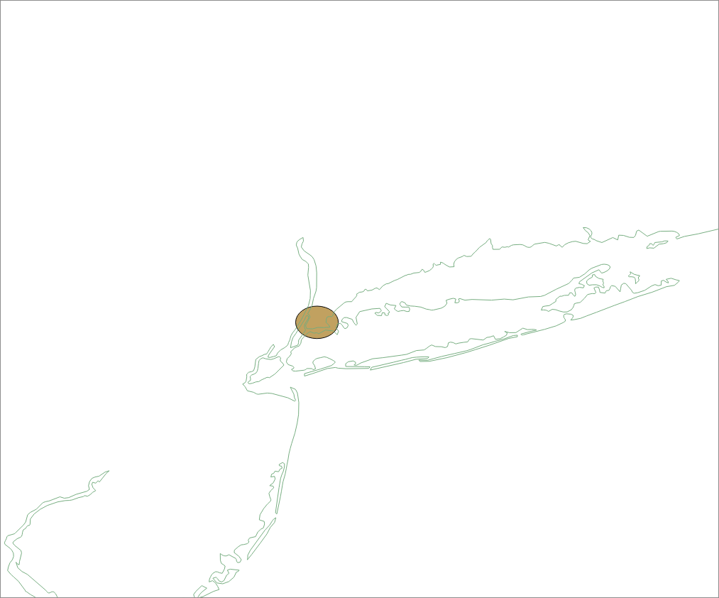
对于你的输入,这给了我一个椭圆在纽约,注意,这是预期的,是由于扭曲的影响,使用非投影的Lat/Lon坐标在一个弯曲的地球。
您可以使用以下方法将其称为:
//Measure<Double, Length> dist = Measure.valueOf(50.0, SI.KILOMETER);
Measure<Double, Length> dist = Measure.valueOf(1.0, NonSI.MILE);
GeometryFactory gf = new GeometryFactory();
Point p = gf.createPoint(new Coordinate(-73.87,40.84));
buf.bufferPoint(dist, DefaultGeographicCRS.WGS84, p);
Stack Overflow用户
发布于 2018-10-17 14:19:13
    double latitude = 40.689234d;
    double longitude = -74.044598d;
    double diameterInMeters = 2000d; //2km

    GeometricShapeFactory shapeFactory = new GeometricShapeFactory();
    shapeFactory.setNumPoints(64); // adjustable
    shapeFactory.setCentre(new Coordinate(latitude, longitude));
    // Length in meters of 1° of latitude = always 111.32 km
    shapeFactory.setWidth(diameterInMeters/111320d);
    // Length in meters of 1° of longitude = 40075 km * cos( latitude ) / 360
    shapeFactory.setHeight(diameterInMeters / (40075000 * Math.cos(Math.toRadians(latitude)) / 360));

    Polygon circle = shapeFactory.createEllipse();
https://stackoverflow.com/questions/44249945
复制相似问题
腾讯云开发者
