
带有多个标记的Google地图自动中心
我创建了一张地图,将我的搜索结果显示为地图上的标记,它几乎是完美的,但是自动中心/缩放并不能按需要工作。地图地址或动态,所以我不能硬编码特定的坐标。
我使用了以前的问题中的一些代码和其他代码来使用界尝试从2个标记中获取坐标并找到中心,但是不管我做了什么,它都不能正常工作。
这是我用的密码--
<!--- SEARCH MAP --->
<div id="map_wrapper">
<div id="map_canvas" class="mapping"></div>
</div>
<?php function getCoordinates($address){
$address = str_replace(" ", "+", $address); // replace all the white space with "+" sign to match with google search pattern
$url = "https://maps.googleapis.com/maps/api/geocode/json?address=$address&key=TOKEN_KEY";
$response = file_get_contents($url);
$json = json_decode($response,TRUE); //generate array object from the response from the web
return ($json['results'][0]['geometry']['location']['lat'].",".$json['results'][0]['geometry']['location']['lng']);
} ?>
<script type="text/javascript">
<?php
$locations = array();
//$location_query = new WP_Query( array(
//'posts_per_page' => 100
// ) );
echo "//markers: 100\n";
echo "var locations = [";
$comma = "";
//while ( $location_query->have_posts() ) {
//$location_query->the_post();
while (have_posts()) {
the_post();
$add = get_post_meta(get_the_ID(), 'address', true);
$property_pin = get_post_meta(get_the_ID(), 'pincode', true);
$terms = wp_get_post_terms(get_the_ID(), 'city');
if ( ! empty( $terms ) && ! is_wp_error( $terms ) ){
foreach ( $terms as $term ) {
if ($term->parent == 0) {
$addy = getCoordinates($add, $term->name);
}
}
}
$title = str_replace("'", "\'", get_the_title());
echo $comma . "['" . $title . "', " . $addy . ", " . get_the_id() . "]";
$comma = ", ";
}
echo "];\n\n";
//info content
echo "var theinfo = [";
$comma2 = "";
while (have_posts()) {
the_post();
$add = get_post_meta(get_the_ID(), 'address', true);
$property_price = get_post_meta(get_the_ID(),'price',true);
$terms = wp_get_post_terms(get_the_ID(), 'city');
if ( ! empty( $terms ) && ! is_wp_error( $terms ) ){
foreach ( $terms as $term ) {
if ($term->parent == 0) { //check for parent terms only
$tcity = $term->name;
}
}
}
$title = str_replace("'", "\'", get_the_title());
$link = get_the_id();
$linkto = '<a href="/property/'.$link.'/">'.$title.'</a>';
$class = 'class="mapmarkers"';
echo $comma2 . "['<div ".$class."><h3>" . $linkto . "</h3><h4>" . $tcity . "</h4><p>$" . $property_price ."</p></div>']";
$comma2 = ", ";
}
echo "];\n\n";
?>
var map;
var bounds = new google.maps.LatLngBounds();
var mapOptions = {
center: new google.maps.LatLng(0, 0),
zoom: 0,
minZoom: 5,
maxZoom: 15,
mapTypeId: 'roadmap'
};
// Display a map on the page
map = new google.maps.Map(document.getElementById("map_canvas"), mapOptions);
map.setTilt(45);
// Info Window Content
var infoWindowContent = theinfo;
// Display multiple markers on a map
var infoWindow = new google.maps.InfoWindow(), marker, i;
// Loop through our array of markers & place each one on the map
for( i = 0; i < locations.length; i++ ) {
var position = new google.maps.LatLng(locations[i][1], locations[i][2]);
marker = new google.maps.Marker({
position: position,
map: map,
title: locations[i][0]
});
//bounds.extend(position);
bounds.extend(marker.getPosition());
// Allow each marker to have an info window
google.maps.event.addListener(marker, 'click', (function(marker, i) {
return function() {
infoWindow.setContent(infoWindowContent[i][0]);
infoWindow.open(map, marker);
}
})(marker, i));
// Automatically center the map fitting all markers on the screen
map.fitBounds(bounds);
map.panToBounds(bounds);
}
// Override our map zoom level once our fitBounds function runs (Make sure it only runs once)
var boundsListener = google.maps.event.addListener((map), 'bounds_changed', function(event) {
this.setZoom(8);
google.maps.event.removeListener(boundsListener);
});
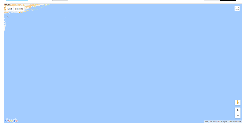
</script>用我的代码,地图是这样绘制的--
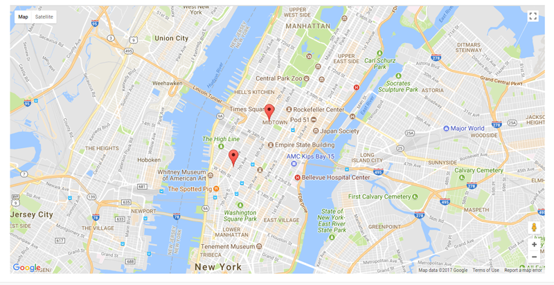
但我需要它更像这样.
示例只使用两个标记,但实际数量和位置将是动态的。我怎么才能解决这个问题?
更新
我的坐标var locations = [['1460 Broadway', 40.7551055,-73.9862093, 2299], ['246 W 18th St', 40.741807,-74.0000351, 2114]];
回答 3
Stack Overflow用户
发布于 2017-12-03 16:37:42
我发现了这个问题,将最外层的地图容器(在问题中没有显示)设置为在页面加载时不显示任何,这样我就可以使用单击函数在map视图和常规的posts列表视图之间切换。
所以我.
    <div id="map_view" style="display:none;">
    <div id="map_wrapper">
    <div id="map_canvas" class="mapping"></div>
    </div>
<script> blah blah </script>
</div>
如果我不显示任何显示,它似乎正确地加载在页面加载。理想情况下,我不希望首先显示地图,但这似乎是迄今为止唯一的解决方案。
Stack Overflow用户
发布于 2017-12-03 06:24:10
TL;DR
对于给定的示例位置和您共享的代码,我无法重现问题:地图视图将正确调整以使位置可见。
现在怎么办?
- 验证程序中的位置数据。
- Are the lat-lon values in the expected range? -> Lat at around 40.7 and lon at around -74
- Are the lat-lon values in the correct order in the locations arrays? -> Lat is at index 1 (as in `locations[i][1]`) and lon is at index 2 (as in `locations[i][2]`)
- 验证您的实际代码是否与已发布的代码->真正匹配,如果发布的代码中缺少一些关键信息,我们可能正在调试错误的东西.
- 将您的问题更新为最小、完整和可验证的示例
- 有关调试过程的更多细节,以及程序的JavaScript部分的一些其他改进想法,请参见下面。
基于您发布的代码和示例locations,我创建了这个最小的示例。与您的代码唯一重要的区别是这个部分,注册一个回调来初始化映射:
<script src="https://maps.googleapis.com/maps/api/js?callback=initMap"
        async defer></script>
在您发布的代码中看不到如何初始化地图。在任何情况下,如果你初始化错误,症状应该不是你的屏幕截图中的地图,而是根本没有地图,所以我想这不是你的问题。但我建议验证一下你的初始化。
请自己尝试这个例子,并在你的问题中确认,如果你能重现它的问题。如果您不能(如我所怀疑的那样),那么为了帮助您,最好是基于此来创建最小、完整和可验证的示例。
<!DOCTYPE html>
<html>
  <head>
    <title>Simple Map</title>
    <meta name="viewport" content="initial-scale=1.0">
    <meta charset="utf-8">
    <style>
      /* Always set the map height explicitly to define the size of the div
       * element that contains the map. */
      #map_canvas {
        height: 100%;
      }
      /* Optional: Makes the sample page fill the window. */
      html, body {
        height: 100%;
        margin: 0;
        padding: 0;
      }
    </style>
  </head>
  <body>
    <div id="map_canvas"></div>
    <script>
function initMap() {
  var locations = [
    ['1460 Broadway', 40.7551055,-73.9862093, 2299],
    ['246 W 18th St', 40.741807,-74.0000351, 2114]
  ];
  var map;
  var bounds = new google.maps.LatLngBounds();
  var mapOptions = {
    center: new google.maps.LatLng(0, 0),
    zoom: 0,
    minZoom: 5,
    maxZoom: 15,
    mapTypeId: 'roadmap'
  };

  // Display a map on the page
  map = new google.maps.Map(document.getElementById("map_canvas"), mapOptions);
  map.setTilt(45);

  // Info Window Content
  var infoWindowContent = locations;  // suitable dummy value

  // Display multiple markers on a map
  var infoWindow = new google.maps.InfoWindow(), marker, i, position;

  // Loop through our array of markers & place each one on the map
  for (i = 0; i < locations.length; i++) {
    position = new google.maps.LatLng(locations[i][1], locations[i][2]);
    marker = new google.maps.Marker({
      position: position,
      map: map,
      title: locations[i][0]
    });
    bounds.extend(position);

    // Allow each marker to have an info window
    google.maps.event.addListener(marker, 'click', (function(marker, i) {
      return function() {
        infoWindow.setContent(infoWindowContent[i][0]);
        infoWindow.open(map, marker);
      }
    })(marker, i));

    // Automatically center the map fitting all markers on the screen
    map.fitBounds(bounds);
    map.panToBounds(bounds);
  }

  // Override our map zoom level once our fitBounds function runs (Make sure it only runs once)
  var boundsListener = google.maps.event.addListener((map), 'bounds_changed', function(event) {
    this.setZoom(8);
    google.maps.event.removeListener(boundsListener);
  });
}
    </script>
    <script src="https://maps.googleapis.com/maps/api/js?callback=initMap"
            async defer></script>
  </body>
</html>
这就是输出的样子:
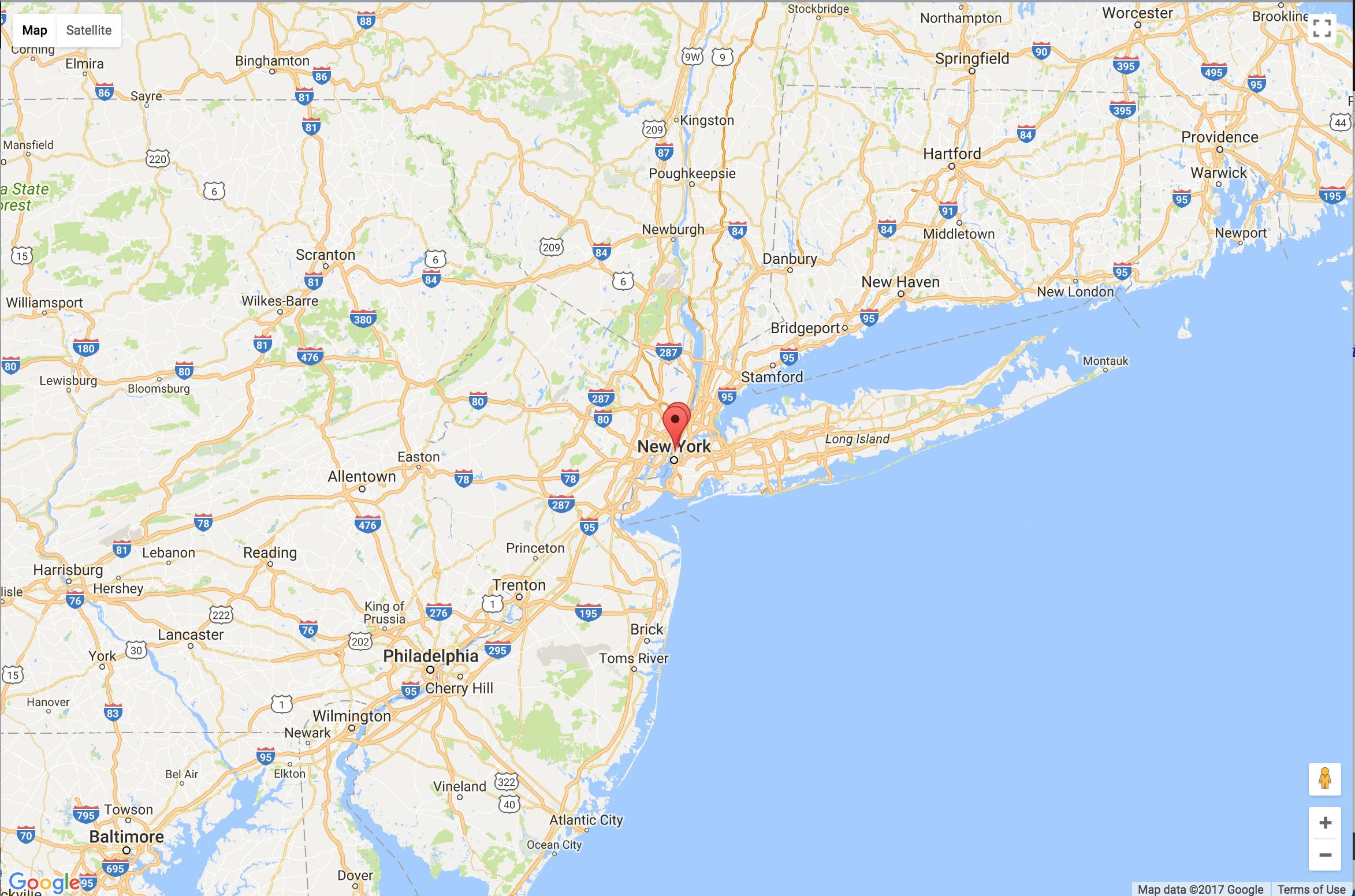
这不是很好,但是这些点在可见光的中心,和我们在你的帖子中看到的非常不同。我真的觉得你错过了一些重要的细节。
在这一点上,可以做一些简单的改进:
- 缩放级别8不适合这些点,让我们将其删除为
- 既然这是
boundsListener唯一的工作,我们也放弃吧 - 注意,
boundsListener从一开始就显得毫无意义,因为您已经调用了map.fitBounds和map.panToBounds
- 既然这是
- 与其对每个点调用
map.fitBounds和map.panToBounds,我们可以将其移出循环,并在将所有点添加到bounds之后调用它。
根据上述建议,代码的JavaScript部分如下:
function initMap() {
  var locations = [
    ['1460 Broadway', 40.7551055,-73.9862093, 2299],
    ['246 W 18th St', 40.741807,-74.0000351, 2114]
  ];
  var map;
  var bounds = new google.maps.LatLngBounds();
  var mapOptions = {
    center: new google.maps.LatLng(0, 0),
    zoom: 0,
    minZoom: 5,
    maxZoom: 15,
    mapTypeId: 'roadmap'
  };

  // Display a map on the page
  map = new google.maps.Map(document.getElementById("map_canvas"), mapOptions);
  map.setTilt(45);

  // Info Window Content
  var infoWindowContent = locations;  // suitable dummy value

  // Display multiple markers on a map
  var infoWindow = new google.maps.InfoWindow(), marker, i, position;

  // Loop through our array of markers & place each one on the map
  for (i = 0; i < locations.length; i++) {
    position = new google.maps.LatLng(locations[i][1], locations[i][2]);
    marker = new google.maps.Marker({
      position: position,
      map: map,
      title: locations[i][0]
    });
    bounds.extend(position);

    // Allow each marker to have an info window
    google.maps.event.addListener(marker, 'click', (function(marker, i) {
      return function() {
        infoWindow.setContent(infoWindowContent[i][0]);
        infoWindow.open(map, marker);
      }
    })(marker, i));
  }

  // Automatically center the map fitting all markers on the screen
  map.fitBounds(bounds);
  map.panToBounds(bounds);
}
输出结果如下:
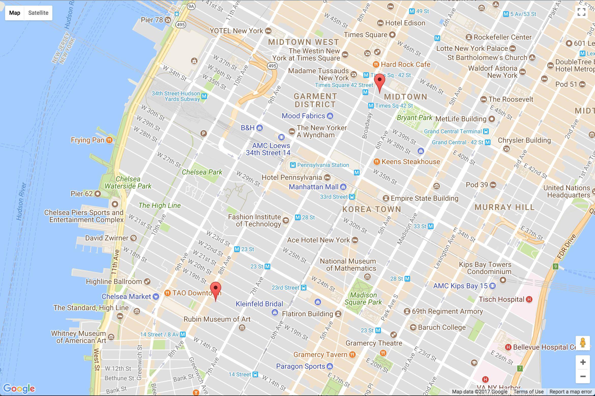
到目前为止,我只能从你提供的信息中了解到这一点。我看不出有什么问题。
我希望上面的内容将有助于您的调试,或者在此基础上您将发布一个最小、完整和可验证的示例,以帮助其他人发现您的问题。
Stack Overflow用户
发布于 2017-12-05 12:09:27
也许这能帮到一个人。如果您需要在您的标记周围添加一个涟漪,您可以这样做。您可以根据您的需求为所有或部分标记添加波纹。
    <!DOCTYPE html>
    <html>
    <head>
    <meta http-equiv="content-type" content="text/html; charset=UTF-8" />
   <title>Google Maps Multiple Markers</title>
  <script src="http://maps.google.com/maps/api/js?sensor=false"
          type="text/javascript"></script>
</head>
<body>
  <div id="map" style="width: 1000px; height: 500px;"></div>

   <script type="text/javascript">
     var locations = [
     ['Saudi Arabia',23.885942, 45.079162   , 6],
      ['United Arab Emirates', 23.424076, 53.847818, 4],
      ['Bahrain',25.930414  ,50.637772  , 5],
      ['Iraq',  33.223191,  43.679291   , 3],
      ['Kuwait',29.31166,   47.481766   , 2],
      ['Qatar',25.354826,   51.183884   , 1]
    ];

    var map = new google.maps.Map(document.getElementById('map'), {
      zoom: 10,
      center: new google.maps.LatLng(23.885942, 45.079162),
      mapTypeId: google.maps.MapTypeId.ROADMAP
    });

    var infowindow = new google.maps.InfoWindow();

    var marker, i;

    var icon = {
                url: "Ripple.svg", // url of ripple svg image
                scaledSize: new google.maps.Size(200, 200), // scaled size
                origin: new google.maps.Point(0,0), // origin
                anchor: new google.maps.Point(100,100) // anchor
            };

  for (i = 0; i < locations.length; i++) {
      marker = new google.maps.Marker({

        position: new google.maps.LatLng(locations[i][1], locations[i][2]),
        map: map,
         icon: icon,
            optimized: false
      });

       google.maps.event.addListener(marker, 'click', (function(marker, i) {
        return function() {
          infowindow.setContent(locations[i][0]);
          infowindow.open(map, marker);
        }
      })(marker, i));
      }
for (i = 0; i < locations.length; i++) {
      marker = new google.maps.Marker({
        position: new google.maps.LatLng(locations[i][1], locations[i][2]),
        map: map
      });

      google.maps.event.addListener(marker, 'click', (function(marker, i) {
        return function() {
          infowindow.setContent(locations[i][0]);
          infowindow.open(map, marker);
        }
      })(marker, i));
    }


  </script>
</body>
</html>
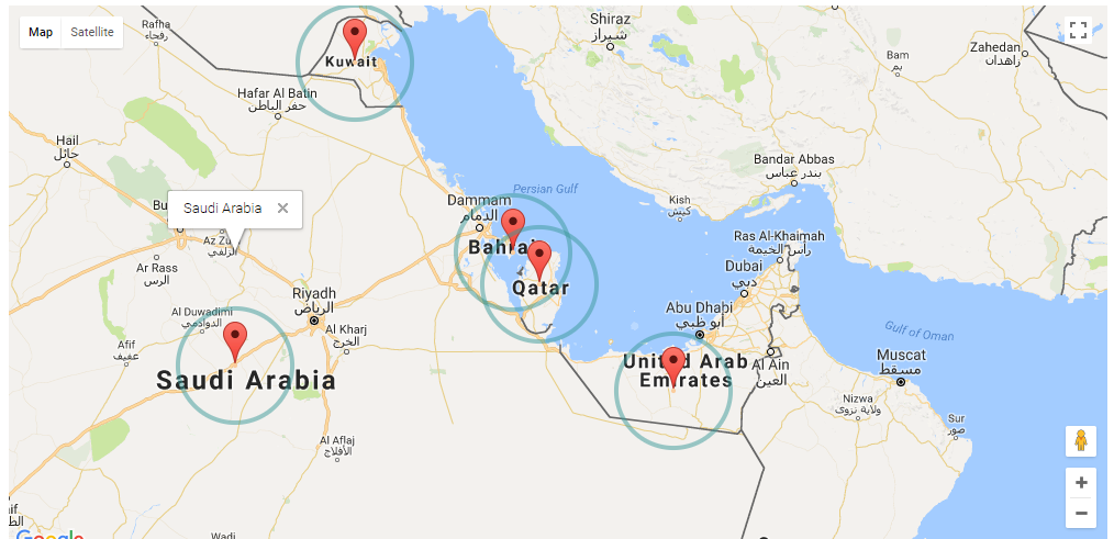
]3.
https://stackoverflow.com/questions/47558974
复制相似问题
腾讯云开发者
