Google Earth Engine ——MYD10A1 V6 Snow Cover Daily Global 500m产品包含雪盖、雪反照率、雪盖分率和质量评估(QA)数据归一化差异积雪指数数据集

Google Earth Engine ——MYD10A1 V6 Snow Cover Daily Global 500m产品包含雪盖、雪反照率、雪盖分率和质量评估(QA)数据归一化差异积雪指数数据集

此星光明
发布于 2024-02-02 11:09:49
发布于 2024-02-02 11:09:49
The MYD10A1 V6 Snow Cover Daily Global 500m product contains snow cover, snow albedo, fractional snow cover, and quality assessment (QA) data. Snow cover data are based on a snow mapping algorithm that employs a Normalized Difference Snow Index (NDSI) and other criteria tests.
MYD10A1 V6 Snow Cover Daily Global 500m产品包含雪盖、雪反照率、雪盖分率和质量评估(QA)数据。积雪覆盖数据是基于采用归一化差异积雪指数(NDSI)和其他标准测试的积雪制图算法。
Dataset Availability
2002-07-04T00:00:00 - 2021-09-22T00:00:00
Dataset Provider
Collection Snippet
ee.ImageCollection("MODIS/006/MYD10A1")
Resolution
500 meters
Bands Table
Name | Description | Min | Max | Scale |
|---|---|---|---|---|
NDSI_Snow_Cover | NDSI snow cover. This value is computed for MOD10_L2 and retrieved when the observation of the day is selected. Provider values above 100 are masked out in this band (they can be found in the "NDSI_Snow_Cover_Class" band). | 0 | 100 | 0 |
NDSI_Snow_Cover_Basic_QA | A basic estimate of the quality of the algorithm result. This value is computed for MOD10_L2 and retrieved with the corresponding observation of the day. | 0 | ||
NDSI_Snow_Cover_Basic_QA Bitmask | Bits 0-15: QA 0: Best1: Good2: Ok3: Poor - not currently in use211: Night239: Ocean | |||
NDSI_Snow_Cover_Algorithm_Flags_QA | Bit flags indicating screen results and the presence of inland water. These flags are set when MOD10_L2 is generated and retrieved with the corresponding observation of the day. | 0 | ||
NDSI_Snow_Cover_Algorithm_Flags_QA Bitmask | Bit 0: Inland water 0: No1: YesBit 1: Low visible screen failed. Snow detection reversed. 0: No fail/not reversed1: The MODIS band 2 reflectance is ≤ 0.10 or the band 4 reflectance is ≤ 0.11Bit 2: Low NDSI screen failed. Snow detection reversed. 0: No fail/not reversed1: Pixels detected as having snow cover with 0.0 < NDSI < 0.10 are reversed to no snowBit 3: Combined temperature/height screen failed. 1: Brightness temperature ≥ 281K, pixel height < 1300m, flag set, snow detection reversed to not snow or brightness temperature ≥ 281K, pixel height ≥ 1300m, flag set, snow detection NOT reversed.Bit 4: Shortwave IR (SWIR) reflectance anomalously high. 1: Snow pixel with SWIR > 0.45, flag set, snow detection reversed to not snow or snow pixel with 25% < SWIR ≤ 45%, flag set to indicate unusual snow condition, snow detection NOT reversed.Bit 5: Spare 0: N/ABit 6: Spare 0: N/ABit 7: Solar zenith screen failed (angles exceed 70°), uncertainty increased. 0: No1: Yes | |||
NDSI | Raw NDSI (i.e. prior to screening). This value is computed for MOD10_L2 and retrieved with the corresponding observation of the day. | 0 | 10000 | 0.0001 |
Snow_Albedo_Daily_Tile | Snow albedo percentage. Provider values above 100 are masked out in this band (they can be found in the "Snow_Albedo_Daily_Tile_Class" band).' | 1 | 100 | 0 |
orbit_pnt | Pointer to the orbit number of the swath that was selected as the observation of the day. The pointer references by index the list of orbit numbers written to the ORBITNUMBERARRAY metadata object in ArchiveMetadata.0. | 0 | ||
granule_pnt | Pointer to the granule (swath) that was mapped into the tile. The pointer references the corresponding value in the GRANULEPOINTERARRAY metadata object written to ArchiveMetadata.0. | 0 | ||
NDSI_Snow_Cover_Class | Landcover classes from the "NDSI_Snow_Cover" subdataset (provider values less than or equal to 100 are masked out). | 0 | ||
Snow_Albedo_Daily_Tile_Class | Landcover classes from the "Snow_Albedo_Daily_Tile" subdataset (provider values less than or equal to 100 are masked out). | 0 | ||
- Bits 0-15: QA
- 0: Best
- 1: Good
- 2: Ok
- 3: Poor - not currently in use
- 211: Night
- 239: Ocean
NDSI_Snow_Cover_Algorithm_Flags_QABit flags indicating screen results and the presence of inland water. These flags are set when MOD10_L2 is generated and retrieved with the corresponding observation of the day.0NDSI_Snow_Cover_Algorithm_Flags_QA Bitmask
- Bit 0: Inland water
- 0: No
- 1: Yes
- Bit 1: Low visible screen failed. Snow detection reversed.
- 0: No fail/not reversed
- 1: The MODIS band 2 reflectance is ≤ 0.10 or the band 4 reflectance is ≤ 0.11
- Bit 2: Low NDSI screen failed. Snow detection reversed.
- 0: No fail/not reversed
- 1: Pixels detected as having snow cover with 0.0 < NDSI < 0.10 are reversed to no snow
- Bit 3: Combined temperature/height screen failed.
- 1: Brightness temperature ≥ 281K, pixel height < 1300m, flag set, snow detection reversed to not snow or brightness temperature ≥ 281K, pixel height ≥ 1300m, flag set, snow detection NOT reversed.
- Bit 4: Shortwave IR (SWIR) reflectance anomalously high.
- 1: Snow pixel with SWIR > 0.45, flag set, snow detection reversed to not snow or snow pixel with 25% < SWIR ≤ 45%, flag set to indicate unusual snow condition, snow detection NOT reversed.
- Bit 5: Spare
- 0: N/A
- Bit 6: Spare
- 0: N/A
- Bit 7: Solar zenith screen failed (angles exceed 70°), uncertainty increased.
- 0: No
- 1: Yes
NDSIRaw NDSI (i.e. prior to screening). This value is computed for MOD10_L2 and retrieved with the corresponding observation of the day.0100000.0001Snow_Albedo_Daily_TileSnow albedo percentage. Provider values above 100 are masked out in this band (they can be found in the "Snow_Albedo_Daily_Tile_Class" band).'11000orbit_pntPointer to the orbit number of the swath that was selected as the observation of the day. The pointer references by index the list of orbit numbers written to the ORBITNUMBERARRAY metadata object in ArchiveMetadata.0.0granule_pntPointer to the granule (swath) that was mapped into the tile. The pointer references the corresponding value in the GRANULEPOINTERARRAY metadata object written to ArchiveMetadata.0.0NDSI_Snow_Cover_ClassLandcover classes from the "NDSI_Snow_Cover" subdataset (provider values less than or equal to 100 are masked out).0Snow_Albedo_Daily_Tile_ClassLandcover classes from the "Snow_Albedo_Daily_Tile" subdataset (provider values less than or equal to 100 are masked out).0
Class Table: NDSI_Snow_Cover_Class
Value | Color | Color Value | Description |
|---|---|---|---|
200 | # | Missing data | |
201 | # | No decision | |
211 | # | Night | |
237 | # | Inland water | |
239 | # | Ocean | |
250 | # | Cloud | |
254 | # | Detector saturated |
Class Table: Snow_Albedo_Daily_Tile_Class
Value | Color | Color Value | Description |
|---|---|---|---|
101 | # | No decision | |
111 | # | Night | |
125 | # | Land | |
137 | # | Inland water | |
139 | # | Ocean | |
150 | # | Cloud | |
151 | # | Cloud detected as snow | |
250 | # | Missing | |
251 | # | Self-shadowing | |
252 | # | Land mask mismatch | |
253 | # | BRDF failure | |
254 | # | Non-production mask |
使用说明:
You may download and use photographs, imagery, or text from the NSIDC web site, unless limitations for its use are specifically stated. For more information on usage and citing NSIDC datasets, please visit the NSIDC 'Use and Copyright' page
引用:Hall, D. K., V. V. Salomonson, and G. A. Riggs. 2016. MODIS/Terra Snow Cover Daily L3 Global 500m Grid. Version 6. Boulder, Colorado USA: NASA National Snow and Ice Data Center Distributed Active Archive Center.
MODIS/Aqua Snow Cover Daily L3 Global 500m SIN Grid, Version 6 | National Snow and Ice Data Center
代码:
var dataset = ee.ImageCollection('MODIS/006/MYD10A1')
                  .filter(ee.Filter.date('2018-01-01', '2018-05-01'));
var snowCover = dataset.select('NDSI_Snow_Cover');
var snowCoverVis = {
  min: 0.0,
  max: 100.0,
  palette: ['black', '0dffff', '0524ff', 'ffffff'],
};
Map.setCenter(-38.13, 40, 2);
Map.addLayer(snowCover, snowCoverVis, 'Snow Cover');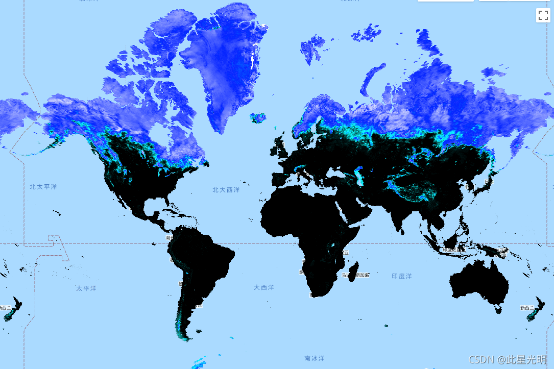
本文参与 腾讯云自媒体同步曝光计划,分享自作者个人站点/博客。
原始发表:2024-02-01,如有侵权请联系 cloudcommunity@tencent.com 删除
评论
登录后参与评论
推荐阅读
腾讯云开发者

Copyright © 2013 - 2026 Tencent Cloud. All Rights Reserved. 腾讯云 版权所有
深圳市腾讯计算机系统有限公司 ICP备案/许可证号:粤B2-20090059 ![]() 粤公网安备44030502008569号
粤公网安备44030502008569号
腾讯云计算(北京)有限责任公司 京ICP证150476号 | 京ICP备11018762号