Google Earth Engine ——ALOS World 3D - 30m (AW3D30) 是一个全球数字表面模型 (DSM) V3_2版本数据集

Google Earth Engine ——ALOS World 3D - 30m (AW3D30) 是一个全球数字表面模型 (DSM) V3_2版本数据集

此星光明
发布于 2024-02-02 09:15:59
发布于 2024-02-02 09:15:59
ALOS World 3D - 30m (AW3D30) is a global digital surface model (DSM) dataset with a horizontal resolution of approximately 30 meters (1 arcsec mesh). The dataset is based on the DSM dataset (5-meter mesh version) of the World 3D Topographic Data. More details are available in the dataset documentation.
Version 3.2, released in January 2021, is an improved version created by reconsidering the format in the high latitude area, auxiliary data, and processing method. Different pixel spacing for each latitude zone was adopted at high latitude area. Coastline data, which is one of the auxiliary datasets, was changed, and new supplementary data was used. In addition, as a source data for Japan, AW3D version 3 was also used. Furthermore, the method of detecting anomalous values in the process was improved.
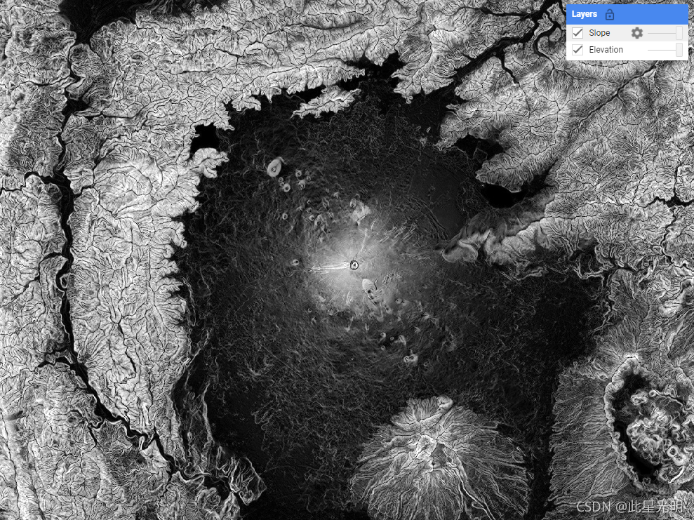
Note: See the code example for the recommended way of computing slope. Unlike most DEMs in Earth Engine, this is an image collection due to multiple resolutions of source files that make it impossible to mosaic them into a single asset, so the slope computations need a reprojection.
The AW3D DSM elevation is calculated by an image matching process that uses a stereo pair of optical images. Clouds, snow, and ice are automatically identified during processing and applied the mask information. However, mismatched points sometimes remain especially surrounding (or at the edges of) clouds, snow, and ice areas, which cause some height errors in the final DSM. Here are some example areas with data values outside of valid elevation range. Impossibly low negative values are concentrated in Antarctica around (-63.77, -61.660), (-77.22, -150.27), and (-73.29, 168.14); in Indonesia around (-5.36, 134.55); in Brazil around (-1.667113844, -50.6269684); and in Peru around (-10.45048137, -75.39459876) with approximate values of -1013, -998, -635, and -610 respectively. Impossibly high positive values are found in several locations in the Arctic around (79.83, -77.67) and (69.54, -75.42); in Fiji around (-16.58, 179.44) and (-18.96, 178.39); and in Nepal around (28.50, 84.56) with approximate values of 15369, 15213, and 10900 respectively.
ALOS World 3D - 30m (AW3D30) 是一个全球数字表面模型 (DSM) 数据集,水平分辨率约为 30 米(1 弧秒网格)。该数据集基于 World 3D Topographic Data 的 DSM 数据集(5 米网格版本)。数据集文档中提供了更多详细信息。

2021年1月发布的3.2版本,是对高纬度地区的格式、辅助数据、处理方式等进行重新思考而创建的改进版本。高纬度地区对每个纬度区采用不同的像素间距。作为辅助数据集之一的海岸线数据进行了更改,并使用了新的补充数据。此外,作为日本的源数据,还使用了 AW3D 版本 3。此外,改进了检测过程中异常值的方法。

注意:推荐的斜率计算方法见代码示例。与 Earth Engine 中的大多数 DEM 不同,这是一个图像集合,因为源文件具有多种分辨率,因此无法将它们镶嵌到单个资产中,因此斜率计算需要重新投影。

AW3D DSM 高程是通过使用一对立体光学图像的图像匹配过程计算出来的。云、雪和冰在处理过程中自动识别并应用蒙版信息。然而,不匹配的点有时会特别存在于云、雪和冰区周围(或边缘),这会导致最终 DSM 中出现一些高度错误。以下是一些数据值超出有效海拔范围的示例区域。极低的负值集中在南极洲 (-63.77, -61.660)、(-77.22, -150.27) 和 (-73.29, 168.14) 附近;在印度尼西亚附近 (-5.36, 134.55);在巴西附近 (-1.667113844, -50.6269684);在秘鲁 (-10.45048137, -75.39459876) 附近,近似值分别为 -1013、-998、-635 和 -610。在北极的几个位置(79.83,-77.67)和(69.54,-75.42)附近发现了不可能的高正值;在斐济大约 (-16.58, 179.44) 和 (-18.96, 178.39);在尼泊尔 (28.50, 84.56) 附近,近似值分别为 15369、15213 和 10900。
Dataset Availability
2006-01-24T00:00:00 - 2011-05-12T00:00:00
Dataset Provider
JAXA Earth Observation Research Center
Collection Snippet
Copied
ee.ImageCollection("JAXA/ALOS/AW3D30/V3_2")
Resolution
30 meters
Bands Table
Name | Description | Min* | Max* |
|---|---|---|---|
DSM | Height above sea level. Signed 16 bits. Elevation (in meter) converted from the ellipsoidal height based on ITRF97 and GRS80, using EGM96†1 geoid model. | -433 | 8768 |
STK | Stacking number of the scene unit DSM used in producing DSM. The band is derived by resampling the stacking number for 5m resolution DSM to 30m resolution. | 1 | 54 |
MSK | 8-bit mask for the band. | ||
MSK Bitmask | Bits 0-7: Generated from resampled DSM. 0: Valid1: Cloud and snow mask (invalid).2: Land water and low correlation mask (valid).3: Sea mask (valid).4: Void filled with GSI DTM (valid).8: Void filled with Shuttle Radar Topography Mission SRTM-1 Version 3 (valid).12: Void filled with PRISM DSM (valid).16: Void filled with ViewFinder Panoramas DEM (valid).24: Void filled with ASTER GDEM v2 (valid).28: Void filled with ArcticDEM v2 (valid).32: Void filled with TanDEM-X 90m DEM (valid).36: Void filled with ArcticDEM v3 (valid).40: Void filled with ASTER GDEM v3 (valid).44: Void filled with REMA v1.1 (valid).252: Void filled with applied IDW method (gdal_fillnodata) (valid) | ||
- Bits 0-7: Generated from resampled DSM.
- 0: Valid
- 1: Cloud and snow mask (invalid).
- 2: Land water and low correlation mask (valid).
- 3: Sea mask (valid).
- 4: Void filled with GSI DTM (valid).
- 8: Void filled with Shuttle Radar Topography Mission SRTM-1 Version 3 (valid).
- 12: Void filled with PRISM DSM (valid).
- 16: Void filled with ViewFinder Panoramas DEM (valid).
- 24: Void filled with ASTER GDEM v2 (valid).
- 28: Void filled with ArcticDEM v2 (valid).
- 32: Void filled with TanDEM-X 90m DEM (valid).
- 36: Void filled with ArcticDEM v3 (valid).
- 40: Void filled with ASTER GDEM v3 (valid).
- 44: Void filled with REMA v1.1 (valid).
- 252: Void filled with applied IDW method (gdal_fillnodata) (valid)
* = Values are estimated
数据引用说明:
This dataset is available to use with no charge under the conditions specified in the Terms of use for ALOS Global Digital Surface Model.
T. Tadono, H. Ishida, F. Oda, S. Naito, K. Minakawa, H. Iwamoto : Precise Global DEM Generation By ALOS PRISM, ISPRS Annals of the Photogrammetry, Remote Sensing and Spatial Information Sciences, Vol.II-4, pp.71-76, 2014. PDF file
J. Takaku, T. Tadono, K. Tsutsui : Generation of High Resolution Global DSM from ALOS PRISM, The International Archives of the Photogrammetry, Remote Sensing and Spatial Information Sciences, Vol. XL-4, pp.243-248, ISPRS, 2014. PDF file
J. Takaku, T. Tadono, K. Tsutsui, M. Ichikawa : Validation of ‘AW3D’ Global DSM Generated from ALOS PRISM, ISPRS Annals of the Photogrammetry, Remote Sensing and Spatial Information Sciences, Vol.III-4, pp.25-31, 2016. PDF file
T. Tadono, H. Nagai, H. Ishida, F. Oda, S. Naito, K. Minakawa, H. Iwamoto : Initial Validation of the 30 m-mesh Global Digital Surface Model Generated by ALOS PRISM, The International Archives of the Photogrammetry, Remote Sensing and Spatial Information Sciences, ISPRS, Vol. XLI-B4, pp.157-162, 2016. PDF file
代码:
var dataset = ee.ImageCollection('JAXA/ALOS/AW3D30/V3_2');
var elevation = dataset.select('DSM');
var elevationVis = {
min: 0,
max: 5000,
palette: ['0000ff', '00ffff', 'ffff00', 'ff0000', 'ffffff']
};
Map.setCenter(138.73, 35.36, 11);
Map.addLayer(elevation, elevationVis, 'Elevation');
// Reproject an image mosaic using a projection from one of the image tiles,
// rather than using the default projection returned by .mosaic().
var proj = elevation.first().select(0).projection();
var slopeReprojected = ee.Terrain.slope(elevation.mosaic()
.setDefaultProjection(proj));
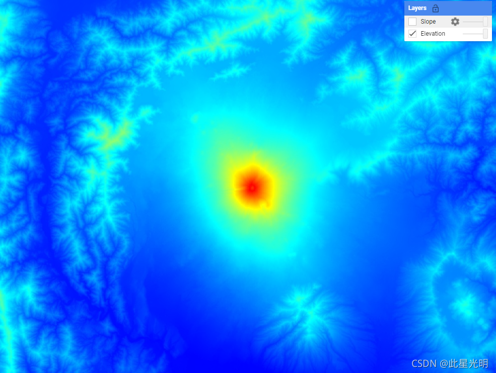
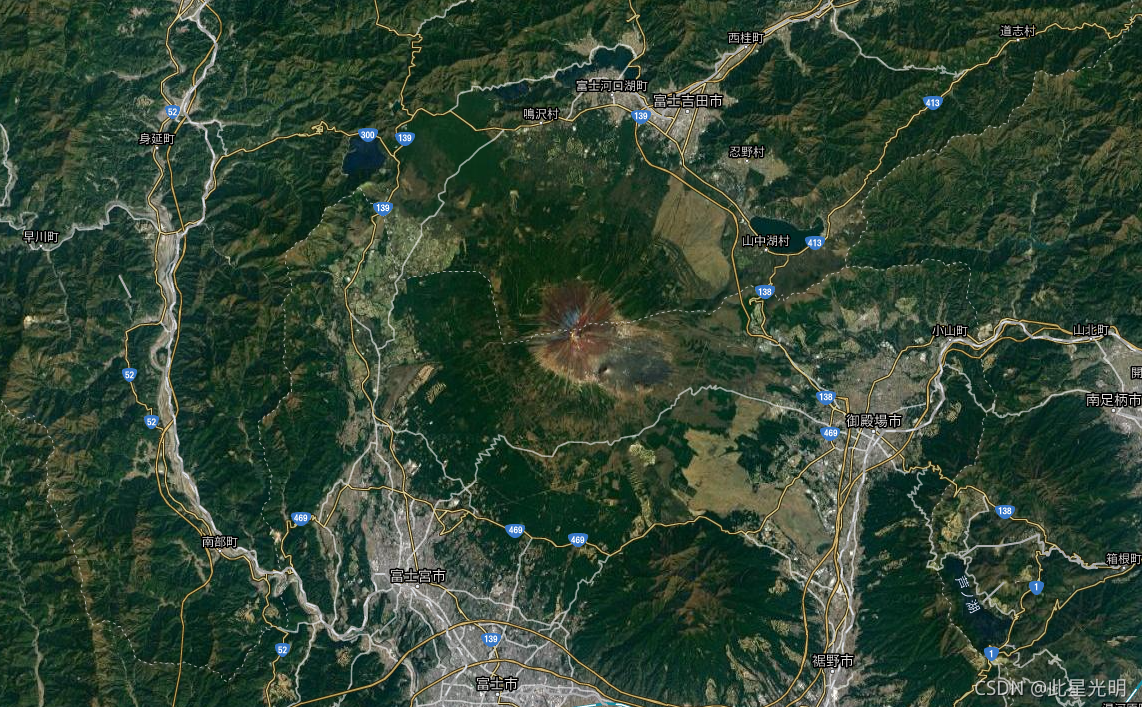
Map.addLayer(slopeReprojected, {min: 0, max: 45}, 'Slope');日本富士山
本文参与 腾讯云自媒体同步曝光计划,分享自作者个人站点/博客。
原始发表:2024-02-01,如有侵权请联系 cloudcommunity@tencent.com 删除
评论
登录后参与评论
推荐阅读
腾讯云开发者

Copyright © 2013 - 2026 Tencent Cloud. All Rights Reserved. 腾讯云 版权所有
深圳市腾讯计算机系统有限公司 ICP备案/许可证号:粤B2-20090059 ![]() 粤公网安备44030502008569号
粤公网安备44030502008569号
腾讯云计算(北京)有限责任公司 京ICP证150476号 | 京ICP备11018762号